 Filter: Categories of Wisconsin Historical Images
Filter: FULL_DATE of 1938
Filter: Subject of rivers
Filter: Categories of Wisconsin Historical Images
Filter: FULL_DATE of 1938
Filter: Subject of rivers
| Date: | 1938 |
|---|---|
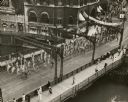
| Description: | Elevated view. As part of Boy Scout Day at the Wisconsin State Fair, a contingent of scout flag bearers marches over the Wisconsin Avenue Bridge over the M... |
| Date: | 1938 |
|---|---|
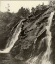
| Description: | Little Manitou Falls on the Black River. Referred to as the "upper falls" in the park. A person is sitting on the rocks on top of the falls. This waterfall... |
| Date: | 1938 |
|---|---|
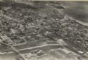
| Description: | Aerial view of rivers, with Lake Michigan in upper right, train yards, and highway in lower left. |
| Date: | 1938 |
|---|---|
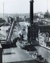
| Description: | Elevated view of a tugboat pulling a lake steamer on the Milwaukee River under an open drawbridge near the Electric Company. |

| Date: | 1938 |
|---|---|
| Description: | A man in the distance is sitting in a field, with a covered bridge behind him spanning a river. Trees are at each end of the bridge, and a fence runs along... |
| Date: | 1938 |
|---|---|
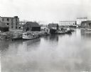
| Description: | Elevated view of a boat owned by Julius Dettloff docked along the edge of a river. The boat was powered by an International PD-40 power unit; in the backgr... |

| Date: | 1938 |
|---|---|
| Description: | This map shows lakes, rivers, roads, trails, lookout towers, and railroads. |
| Date: | 1938 |
|---|---|
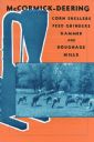
| Description: | Cover of a McCormick-Deering brochure featuring corn shellers, feed grinders, hammer and roughage mills. |

| Date: | 1938 |
|---|---|
| Description: | This map shows "regional designation problem areas" and "nature of problem or solution." The left margin has a key showing the problem areas. The right mar... |
| Date: | 1938 |
|---|---|
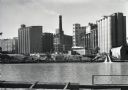
| Description: | View across the Kinnickinnic River of the Pabst brewery grain elevator. A Schlitz building, possibly one of their grain elevators, stands behind the Pabst ... |
| Date: | 1938 |
|---|---|
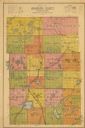
| Description: | Map shows roads, townships and sections, railroads, water, and schools. |

| Date: | 1938 |
|---|---|
| Description: | Color coded map in pink, yellow, blue, and brown of Milwaukee County State and County trunk highways. The map includes a legend of symbols: "STEAM RAIL ROA... |

| Date: | 1938 |
|---|---|
| Description: | The map includes text, illustrations, a railroad fare table (season 1938), a Directory of resorts and hotels, and a regional map on the back. |
| Date: | 1938 |
|---|---|
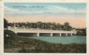
| Description: | Colorized postcard view from shoreline of a stone bridge lined with lampposts. Dwellings and commercial buildings are on the far side. An elevated railroad... |

| Date: | 1938 |
|---|---|
| Description: | This map shows plat of town, land ownership by name, city limits, section boundaries, wards, local roads, railroads, parks, fairgrounds, cemeteries, locati... |

| Date: | 1938 |
|---|---|
| Description: | This map shows the state trunk highway system and county trunk highways. This map show surface type on state and county trunk highways and the locations of... |

| Date: | 1938 |
|---|---|
| Description: | This map shows roads, parks, golf courses, airports, beaches, docks and harbors, lighthouses, and buoys within Winnebago County and parts of Waushara, Calu... |

| Date: | 1938 |
|---|---|
| Description: | This colored road map shows automobile roads in Wisconsin as well as portions of nearby states. Information on the quality and and type of any road shown (... |
| Date: | 1938 |
|---|---|
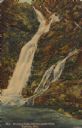
| Description: | Text on front reads: "Manitou Falls, Pattison State Park, Superior, Wis." On reverse: "Manitou Falls, with a specacular drop of 165 ft., is the most outsta... |
If you didn't find the material you searched for, our Library Reference Staff can help.
Call our reference desk at 608-264-6535 or email us at: