 Filter: Categories of Wisconsin Historical Images
Filter: FULL_DATE of 1938
Filter: Subject of parks
Filter: Categories of Wisconsin Historical Images
Filter: FULL_DATE of 1938
Filter: Subject of parks
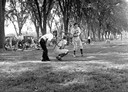
| Date: | 1938 |
|---|---|
| Description: | The catcher squats as the batter gets ready to swing at a pitch while the umpire looks on. This image was taken as part of the WPA Federal Writers Project... |

| Date: | 1938 |
|---|---|
| Description: | View from Capitol Park towards the corner of Monona Avenue and Main Street. |
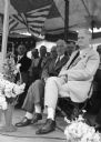
| Date: | 1938 |
|---|---|
| Description: | Dr. Francis E. Townsend seated on the platform of a Townsend Plan Club at a park. |
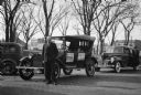
| Date: | 1938 |
|---|---|
| Description: | W. L. Tarnutzer stands beside a 1914 Dodge automobile parked on the Sauk County courthouse square. A newer model Dodge with a woman beside it is parked beh... |

| Date: | 1938 |
|---|---|
| Description: | Advertising brochure for International D-35 and DS-35 trucks. Cover features a photograph of a D-35 owned by Gordon's Transports. |

| Date: | 1938 |
|---|---|
| Description: | Color coded map in pink, yellow, blue, and brown of Milwaukee County State and County trunk highways. The map includes a legend of symbols: "STEAM RAIL ROA... |
| Date: | 1938 |
|---|---|
| Description: | Architectural drawing of the Sunset Village neighborhood on the West side of the city of Madison. The poster description reads: A proposed master plan for ... |

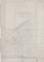
| Date: | 1938 |
|---|---|
| Description: | This map shows buildings, lots, parks, schools, pumping stations, sites reserved for churches, and water towers. |

| Date: | 1938 |
|---|---|
| Description: | This map shows plat of town, land ownership by name, city limits, section boundaries, wards, local roads, railroads, parks, fairgrounds, cemeteries, locati... |

| Date: | 1938 |
|---|---|
| Description: | This map shows roads, parks, golf courses, airports, beaches, docks and harbors, lighthouses, and buoys within Winnebago County and parts of Waushara, Calu... |

| Date: | 1938 |
|---|---|
| Description: | This colored road map shows automobile roads in Wisconsin as well as portions of nearby states. Information on the quality and and type of any road shown (... |

| Date: | 1938 |
|---|---|
| Description: | Scene of a tree and rock-lined road through Vilas Park. Benches are on the lawn on the right. Caption reads: "Pleasure Drive in Vilas Park, Madison, Wiscon... |
If you didn't find the material you searched for, our Library Reference Staff can help.
Call our reference desk at 608-264-6535 or email us at: