| Date: | 1937 |
|---|---|
| Description: | Side elevation of Herbert Jabobs Residence I, designed by Frank Lloyd Wright, during construction. Several of the neighboring houses can be seen behind the... |

| Date: | 1937 |
|---|---|
| Description: | Elevated view across street towards the Methodist Hospital. |

| Date: | 1937 |
|---|---|
| Description: | Exterior view of the 800 block of South Third Street, with three large houses lining the road. |

| Date: | 1937 |
|---|---|
| Description: | Exterior of the house at 702 Walton Place built by Willard Droster. |

| Date: | 1937 |
|---|---|
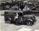
| Description: | A man carrying a box exits the passenger side of an International D-2 panel truck used by the Singer Sewing Machine Company. The text on the box reads: "Si... |

| Date: | 1937 |
|---|---|
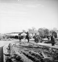
| Description: | Large group of construction workers walking through neighborhood of houses that are in the middle of being constructed. |

| Date: | 1937 |
|---|---|
| Description: | Holiday card of a young boy dressed in a dark blue coat, mittens and hat. The symbol "AAA" on his hat stands for the "American Automobile Association." He ... |

| Date: | 1937 |
|---|---|
| Description: | Sidewalk in front of four houses along Nebraska Row at Madeline Island. Nebraska Row was started by Col. Frederick Woods in 1899 on the bluff at the wester... |

| Date: | 1937 |
|---|---|
| Description: | View from lake of the summer homes on Nebraska Row along the shoreline of Lake Superior. |

| Date: | 1937 |
|---|---|
| Description: | View from the lake of the summer homes on Nebraska Row along the shoreline of Lake Superior. The water tower and church steeple are visible on the far righ... |

| Date: | 1937 |
|---|---|
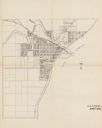
| Description: | This is map 1 from a set of 4 taken from an atlas. The map shows streets, neighborhoods and proposed subdivision. Lake Michigan, Algoma Outer Harbor, the A... |

| Date: | 1937 |
|---|---|
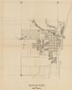
| Description: | This is map 3 from a set of 4 taken from an atlas. The map shows streets, neighborhoods, lots, and railroad tracks. Lake Michigan, the Kewaunee River, and ... |
If you didn't find the material you searched for, our Library Reference Staff can help.
Call our reference desk at 608-264-6535 or email us at: