 Filter: Categories of Wisconsin Historical Images
Filter: FULL_DATE of 1936
Filter: Subject of trails
Filter: Categories of Wisconsin Historical Images
Filter: FULL_DATE of 1936
Filter: Subject of trails

| Date: | 1936 |
|---|---|
| Description: | This map is red and black ink on tracing cloth and is oriented with north to the upper left. This hand-drawn map shows a central portion of the military ro... |
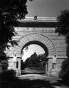
| Date: | 1936 |
|---|---|
| Description: | Camp Randall Memorial Arch with a gated path. |

| Date: | 1936 |
|---|---|
| Description: | This map shows campsites, trails, auto roads, surrounding townships, and points of interest, by including pictorial illustrations. Includes an inserted map... |
If you didn't find the material you searched for, our Library Reference Staff can help.
Call our reference desk at 608-264-6535 or email us at: