Filter: Categories of Wisconsin Historical Images
Filter: FULL_DATE of 1936
Filter: Subject of human settlements
Filter: Creator Name of Unknown
Filter: Categories of Wisconsin Historical Images
Filter: FULL_DATE of 1936
Filter: Subject of human settlements
Filter: Creator Name of Unknown

| Date: | 1936 |
|---|---|
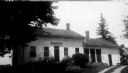
| Description: | View from the east of Hawks Tavern, also known as Hawks Inn. |
| Date: | 1936 |
|---|---|
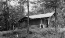
| Description: | View of a Hilbert Lake cottage surrounded by trees and foliage. |

| Date: | 1936 |
|---|---|
| Description: | The residence of Carrie Jacobs Bond. Caption reads: "Residence of Carrie Jacobs Bond, Janesville, Wis." Text in center reads: "Where she wrote 'I Love You ... |
| Date: | 1936 |
|---|---|
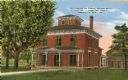
| Description: | Birthplace of Carrie Jacobs Bond. Caption reads: "Birthplace of Carrie Jacobs Bons, Author of 'I Love You Truly', Janesville, Wis." |
| Date: | 1936 |
|---|---|
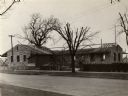
| Description: | Exterior view of Bryant Hall at the Grand Army Home for Veterans. |

| Date: | 1936 |
|---|---|
| Description: | The S.C. Johnson and Son Wax Company building, designed by Frank Lloyd Wright, 1936. |

| Date: | 1936 |
|---|---|
| Description: | A winter view of the Plow (Plough) Inn, sometime before 1936. |

| Date: | 1936 |
|---|---|
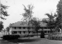
| Description: | Merrill Hall and other smaller buildings from across the street. |
| Date: | 1936 |
|---|---|
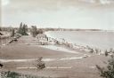
| Description: | Elevated view of Crescent Beach, with campsite with cabins and miniature golf course and other outbuildings. Downtown buildings can be seen in the backgrou... |
| Date: | 1936 |
|---|---|
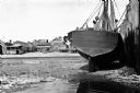
| Description: | View of a fishing boat, 'Stella,' near a dock and wharf. The city's shoreline restaurants can be seen in the background. |

| Date: | 1936 |
|---|---|
| Description: | These two maps of the Town of Conover, Vilas County, Wisconsin, show private land holdings of a section or more as of 1927 and public lands in 1936. Acreag... |

| Date: | 1936 |
|---|---|
| Description: | This 1936 map of Clark County, Wisconsin, shows the township and range grid, sections, cities and town, and lakes and streams in the county. It lacks the k... |

| Date: | 1936 |
|---|---|
| Description: | View from street towards the St. Joseph's Hospital. In the center is a two level open porch, with two people on the second level. A 1930s automobile is par... |

| Date: | 1936 |
|---|---|
| Description: | Winter scene with a gas powered shovel being used to move snow from a snow-covered road. A man is standing in the road to the right, watching. The shovel i... |

| Date: | 1936 |
|---|---|
| Description: | This map shows campsites, trails, auto roads, surrounding townships, and points of interest, by including pictorial illustrations. Includes an inserted map... |

| Date: | 1936 |
|---|---|
| Description: | Raymond (Ray) Griesemer is sitting on his Harley-Davidson motorcycle. He is wearing a jacket, dark pants and boots. In the background is a field with grass... |

| Date: | 1936 |
|---|---|
| Description: | View from Langdon Street towards the front of the Wisconsin Historical Society. Vines cover the stone balustrade and trees are in the foreground. |

| Date: | 1936 |
|---|---|
| Description: | A uniformed police officer stands in an intersection and holds his hand out in the direction of several children. Cars are in the background. Caption reads... |
If you didn't find the material you searched for, our Library Reference Staff can help.
Call our reference desk at 608-264-6535 or email us at: