Filter: Categories of Wisconsin Historical Images
Filter: FULL_DATE of 1936
Filter: Subject of human settlements
Filter: Categories of Wisconsin Historical Images
Filter: FULL_DATE of 1936
Filter: Subject of human settlements

| Date: | 1936 |
|---|---|
| Description: | This map is red and black ink on tracing cloth and is oriented with north to the upper left. This hand-drawn map shows a central portion of the military ro... |
| Date: | 1936 |
|---|---|
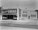
| Description: | Rennebohm Drugstore #12 at 2526 Monroe Street. Originally established by pharmacist Harry Consigny, this operation was purchased by Rennebohm in 1936. |
| Date: | 1936 |
|---|---|
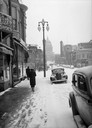
| Description: | Winter scene with people walking in the snow past a lamppost down State and Henry Streets, Madison, Wisconsin. The Wisconsin State Capitol is in the backgr... |
| Date: | 1936 |
|---|---|
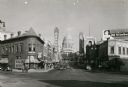
| Description: | State Street view looking east from Johnson Street, towards the Wisconsin State Capitol. On the corner on the left is Glasgow Tailers, and further up the b... |
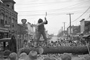
| Date: | 1936 |
|---|---|
| Description: | A crowd surrounds a man as he stands atop a tree trunk swinging his axe in a woodchopping contest. |
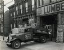
| Date: | 1936 |
|---|---|
| Description: | Workers unloading bags of "plaster of paris" from the back of an International dump truck owned by Azor Building Material Company. Signs on the building an... |
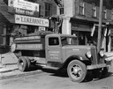
| Date: | 1936 |
|---|---|
| Description: | Man standing in the bed of an International coal delivery truck owned by Thos. J. Kearney Jr., Inc. The man is shoveling coal and the truck is backed up to... |
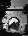
| Date: | 1936 |
|---|---|
| Description: | Camp Randall Memorial Arch with a gated path. |
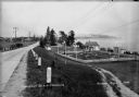
| Date: | 1936 |
|---|---|
| Description: | Crescent Beach campsite with cabins and miniature golf course by Lake Michigan. |
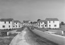
| Date: | 1936 |
|---|---|
| Description: | View down road of mass-produced residential housing with farm in background. |
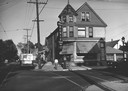
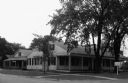
| Date: | 1936 |
|---|---|
| Description: | The Bentz Tavern, located at 3076 N. 12th Street, photographed for the WPA Writers' Project. |
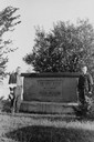
| Date: | 1936 |
|---|---|
| Description: | View of two men posing on either side of the Radisson and Groseilliers House historical marker. The house was the first built by white men in Wisconsin and... |

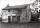
| Date: | 1936 |
|---|---|
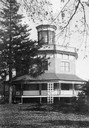
| Description: | Kraus House, lodging operated by Hubert Kraus, and once used as a Civil War drill house. The building was razed in 1936 according to some local residents.... |

| Date: | 1936 |
|---|---|
| Description: | View of the Cushing Memorial monument, located in the vicinity of Delafield. |

| Date: | 1936 |
|---|---|
| Description: | View from the east of Hawks Tavern, also known as Hawks Inn. |
| Date: | 1936 |
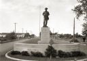
|---|---|
| Description: | View of a boulevard containing a Spanish war memorial statue. The plaque on the statue's base reads: "Memorial to those who served in the war with Spain, 1... |

| Date: | 1936 |
|---|---|
| Description: | View of the panther intaglio effigy mound marker, located on Highway 106 West. The text on the marker reads: "Indian Intaglio Effigy; Panther Type, Length ... |
| Date: | 1936 |
|---|---|
| Description: | Fort Howard Hopital, with an antique dealer next door. |
| Date: | 1936 |
|---|---|
| Description: | North elevation of the Jeremiah Curtin house, located at 8685 West Grange Avenue. This stone and stucco residence was erected in 1835. It has been recogniz... |
If you didn't find the material you searched for, our Library Reference Staff can help.
Call our reference desk at 608-264-6535 or email us at: