Filter: Categories of Wisconsin Historical Images
Filter: FULL_DATE of 1936
Filter: Subject of cemeteries
Filter: Categories of Wisconsin Historical Images
Filter: FULL_DATE of 1936
Filter: Subject of cemeteries
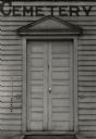
| Date: | 1936 |
|---|---|
| Description: | A view of the Paynesville Cemetery Chapel, entrance detail. |
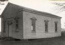
| Date: | 1936 |
|---|---|
| Description: | A view of the Paynesville Cemetery Chapel (south elevation). |
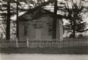
| Date: | 1936 |
|---|---|
| Description: | A view of the Paynesville Cemetery Chapel from the southeast. |

| Date: | 1936 |
|---|---|
| Description: | Street map of the City of Milwaukee and surrounding suburbs indicating various mass transit lines. There is an index to Milwaukee streets at the right of t... |

| Date: | 1936 |
|---|---|
| Description: | This map shows campsites, trails, auto roads, surrounding townships, and points of interest, by including pictorial illustrations. Includes an inserted map... |

| Date: | 1936 |
|---|---|
| Description: | This colored road map shows automobile roads in Wisconsin as well as portions of nearby states. Information on the quality and type of any given road (pave... |
If you didn't find the material you searched for, our Library Reference Staff can help.
Call our reference desk at 608-264-6535 or email us at: