 Filter: Categories of Wisconsin Historical Images
Filter: FULL_DATE of 1935
Filter: Subject of wisconsin river (wis.)
Filter: Categories of Wisconsin Historical Images
Filter: FULL_DATE of 1935
Filter: Subject of wisconsin river (wis.)
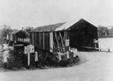
| Date: | 1935 |
|---|---|
| Description: | View of covered bridge above the Wisconsin River, 1 mile from Boscobel. |
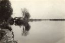
| Date: | 1935 |
|---|---|
| Description: | The Wisconsin River looking downstream. The Wisconsin River end of the canal may be seen at the left. |

| Date: | 1935 |
|---|---|
| Description: | This map shows Wisconsin’s pinery region. Lake Superior, Lake Michigan, Lake Winnebago, Green Bay, the Wisconsin River, and the Mississippi River are label... |

| Date: | 1935 |
|---|---|
| Description: | This road map shows automobile routes across the state of Wisconsin. Advertisements for various hotels are featured along the bottom edge of the map, while... |

| Date: | 1935 |
|---|---|
| Description: | View across water towards an unidentified man sitting in the stern of a small boat, holding a fishing rod. A younger man, sitting forward, is rowing. There... |

| Date: | 1935 |
|---|---|
| Description: | Elevated panoramic view of the Wisconsin River looking north from Tower Hill State Park. There are sandbars in the river. The water tower and village of Sp... |
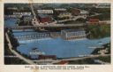
| Date: | 1935 |
|---|---|
| Description: | Text on front reads: "Bird's-eye View of Riverview Service Group, Looking East, At The Dells, Wisconsin Dells, Wisconsin." On reverse: "All the world knows... |
If you didn't find the material you searched for, our Library Reference Staff can help.
Call our reference desk at 608-264-6535 or email us at: