 Filter: Categories of Wisconsin Historical Images
Filter: FULL_DATE of 1935
Filter: Subject of state parks and reserves
Filter: Categories of Wisconsin Historical Images
Filter: FULL_DATE of 1935
Filter: Subject of state parks and reserves
| Date: | 1935 |
|---|---|
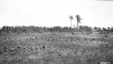
| Description: | Tree planting crew working in Chequamegon National Forest in northern Wisconsin. |
| Date: | 1935 |
|---|---|
| Description: | View from rocky shoreline towards the Brownstone Falls in Copper Falls State Park. |
| Date: | 1935 |
|---|---|
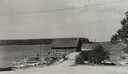
| Description: | View down road towards boats docked at the fishing wharf at Ephraim in Door County. The bluff on the horizon is in Peninsula State Park. |

| Date: | 1935 |
|---|---|
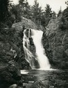
| Description: | View of Bad River rushing over cliff at Copper Falls State Park. |
| Date: | 1935 |
|---|---|
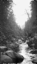
| Description: | The Bad River flowing through boulders and a gorge. |
| Date: | 1935 |
|---|---|
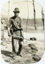
| Description: | Man in work clothes holding a shovel loaded with dirt while another man watches in the background. The men were Civilian Conservation Corps workers at Devi... |
| Date: | 1935 |
|---|---|
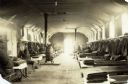
| Description: | Interior view of Civilian Conservation Corps barracks at Devil's Lake State Park. Several men can be seen sitting leisurely on their bunks. Two heating sto... |

| Date: | 1935 |
|---|---|
| Description: | Civilian Conservation Corps workers at the Devil's Lake State park camp waving from trucks. Others men stand in the dirt road nearby. |
| Date: | 1935 |
|---|---|
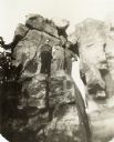
| Description: | Devil's Lake State Park Civilian Conservation Corps workers posed at rock formation, possibly Devil's Doorway. |

| Date: | 1935 |
|---|---|
| Description: | Outdoor informal group portrait of Devil's Lake State Park Civilian Conservation Corps workers. |
| Date: | 1935 |
|---|---|
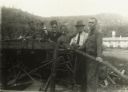
| Description: | Group of Civilian Conservation Corps workers standing at a table saw. One man, probably a supervisor, wears a hat and tie. |

| Date: | 1935 |
|---|---|
| Description: | Two hand-colored maps of the area comprising the town of Millston (Plats of Townships 20 and 21 north, range 2 west), Jackson County, Wisconsin, showing 40... |

| Date: | 1935 |
|---|---|
| Description: | This 1935 map shows the Wisconsin River from a point approximately 4 miles south of the city of Wisconsin Dells north to Duck Creek in Adams County. Sectio... |
| Date: | 1935 |
|---|---|
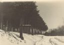
| Description: | View down snowy road through a forest improvement area in Wyalusing State Park. There is a truck in the background, and a sign on the left side of the road... |

| Date: | 1935 |
|---|---|
| Description: | The Works Progress Administration (WPA) used Civilian Conservation Corps (CCC) to build a stone fireplace and landscape an area in Wyalusing State Park (fo... |

| Date: | 1935 |
|---|---|
| Description: | This is WPA (Works Progress Administration) project #8656 of a log and masonry picnic table built by the CCC (Civilian Conservation Corps) at Wyalusing Sta... |

| Date: | 1935 |
|---|---|
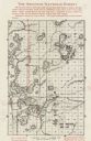
| Description: | This topographical map of the forest preserve shows highways, roads, trails, telephone lines, Native American reservations, Ranger sub-stations, state nurs... |

| Date: | 1935 |
|---|---|
| Description: | This map shows the state trunk highway system and county trunk highways. This map show surface type on state and county trunk highways and the locations of... |
| Date: | 1935 |
|---|---|
| Description: | This map shows land for sale by the company in northwestern part of Nicolet National Forest. The map also shows shoreline acreages, railroads, roads, trail... |
| Date: | 1935 |
|---|---|
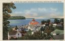
| Description: | Hand-colored elevated view from hill of Ephraim, Eagle Bay and Peninsula State Park. Dwellings and a church are in the foreground. Caption reads: "Ephraim,... |
If you didn't find the material you searched for, our Library Reference Staff can help.
Call our reference desk at 608-264-6535 or email us at: