 Filter: Categories of Wisconsin Historical Images
Filter: FULL_DATE of 1935
Filter: Subject of railroads
Filter: Categories of Wisconsin Historical Images
Filter: FULL_DATE of 1935
Filter: Subject of railroads

| Date: | 1935 |
|---|---|
| Description: | Color brochure advertising the Chicago, Milwaukee, St. Paul & Minneapolis Railroad's Hiawatha, the first streamlined steam locomotive. Hiawatha trains boas... |

| Date: | 1935 |
|---|---|
| Description: | An aerial view of numerous Manitowoc factories/industries. |

| Date: | 1935 |
|---|---|
| Description: | Railroad cars loaded with farm equipment on a track near the loading dock of International Harvester's Magdeburg branch house in Germany. |
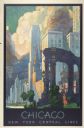
| Date: | 1935 |
|---|---|
| Description: | An original lithograph promoting New York Central Lines railway and the city of Chicago. Featuring the artist Leslie Ragan, the poster depicts the buildin... |

| Date: | 1935 |
|---|---|
| Description: | This 1935 map shows the Wisconsin River from a point approximately 4 miles south of the city of Wisconsin Dells north to Duck Creek in Adams County. Sectio... |

| Date: | 1935 |
|---|---|
| Description: | This map shows streets, railroads, and city wards. Streets, the Oconto River, and the Green Bay are labeled. The bottom of the map reads: "Compliments of O... |
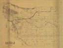
| Date: | 1935 |
|---|---|
| Description: | This map is a photocopy and shows landownership and acreages, additions to Green Bay, points of interest, roads, and railroads. Hand annotations of green,... |

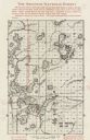
| Date: | 1935 |
|---|---|
| Description: | This topographical map of the forest preserve shows highways, roads, trails, telephone lines, Native American reservations, Ranger sub-stations, state nurs... |

| Date: | 1935 |
|---|---|
| Description: | This map shows railroads, telephone lines, roads, trails, schools, sub-agency, lookout stations, churches, community centers, and school site and farm. Bil... |
| Date: | 1935 |
|---|---|
| Description: | This map shows land for sale by the company in northwestern part of Nicolet National Forest. The map also shows shoreline acreages, railroads, roads, trail... |
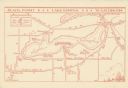
| Date: | 1935 |
|---|---|
| Description: | This map shows Black Point estate including buildings and signs, as well as a school and store near the village of Linton, country clubs, roads, Yerkes Obs... |

| Date: | 1935 |
|---|---|
| Description: | This road map shows automobile routes across the state of Wisconsin. Advertisements for various hotels are featured along the bottom edge of the map, while... |
If you didn't find the material you searched for, our Library Reference Staff can help.
Call our reference desk at 608-264-6535 or email us at: