 Filter: Categories of Wisconsin Historical Images
Filter: FULL_DATE of 1935
Filter: Subject of indian reservations
Filter: Categories of Wisconsin Historical Images
Filter: FULL_DATE of 1935
Filter: Subject of indian reservations

| Date: | 1935 |
|---|---|
| Description: | Menominee Indian Reservation Government School near Shawano. Caption reads: "Government School, Menominee Indian Reservation, Near Shawano, Wis." |
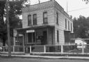
| Date: | 1935 |
|---|---|
| Description: | U.S. Department of the Indian agency building on the Menominee Indian Reservation. |

| Date: | 1935 |
|---|---|
| Description: | "Drott's conservation guide" map shows the locations of Indian reservations, parks, fish hatcheries, forests, lookout towers, Wisconsin Conservations Commi... |

| Date: | 1935 |
|---|---|
| Description: | This topographical map of the forest preserve shows highways, roads, trails, telephone lines, Native American reservations, Ranger sub-stations, state nurs... |

| Date: | 1935 |
|---|---|
| Description: | This map shows railroads, telephone lines, roads, trails, schools, sub-agency, lookout stations, churches, community centers, and school site and farm. Bil... |

| Date: | 1935 |
|---|---|
| Description: | This map shows the state trunk highway system and county trunk highways. This map show surface type on state and county trunk highways and the locations of... |
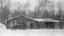
| Date: | 1935 |
|---|---|
| Description: | Two men and a woman are walking from a parked automobile toward the covered porch of the Oshkosh Trading Post, a low, log building on the Menominee Indian ... |
If you didn't find the material you searched for, our Library Reference Staff can help.
Call our reference desk at 608-264-6535 or email us at: