 Filter: Categories of Wisconsin Historical Images
Filter: FULL_DATE of 1935
Filter: Creator Name of Sheboygan City Engineer
Filter: Categories of Wisconsin Historical Images
Filter: FULL_DATE of 1935
Filter: Creator Name of Sheboygan City Engineer
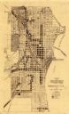
| Date: | 1935 |
|---|---|
| Description: | This map created by the Sheboygan City Engineer department shows five different types of land use in the city in 1935. A legend in the bottom right corner ... |
If you didn't find the material you searched for, our Library Reference Staff can help.
Call our reference desk at 608-264-6535 or email us at: