 Filter: Categories of Wisconsin Historical Images
Filter: FULL_DATE of 1935
Filter: Type of Photograph
Filter: Subject of aerial photographs
Filter: Categories of Wisconsin Historical Images
Filter: FULL_DATE of 1935
Filter: Type of Photograph
Filter: Subject of aerial photographs
| Date: | 1935 |
|---|---|
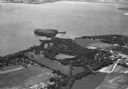
| Description: | Aerial view of Governor's Island in Lake Mendota as well as the area surrounding the Mendota Mental Health Hospital. |
| Date: | 1935 |
|---|---|
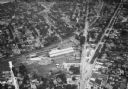
| Description: | Aerial view of the French Battery Company facility, East Washington Avenue, and Winnebago Street at the Union Corners intersection. |
| Date: | 1935 |
|---|---|
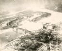
| Description: | An aerial view of La Crosse and the Mississippi River with the bridge drawn in to show what the finished product would look like. |

| Date: | 1935 |
|---|---|
| Description: | An aerial view of numerous Manitowoc factories/industries. |
| Date: | 1935 |
|---|---|
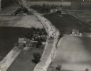
| Description: | Aerial view of the paving operation of Joseph D. Bonners, Inc., on St. Martins Road at Hales Corners. |
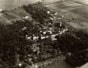
| Date: | 1935 |
|---|---|
| Description: | Aerial view of the Northern Wisconsin Hospital for the Insane. |

| Date: | 1935 |
|---|---|
| Description: | Aerial view of Alex LeTourneau's Resort on Spider Lake. |

| Date: | 1935 |
|---|---|
| Description: | Aerial view of Madeline Island including the tennis courts, houses, and the Old Mission Inn. |
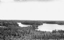
| Date: | 1935 |
|---|---|
| Description: | Elevated view overlooking Lake Mercer and surrounding forest. |
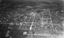
| Date: | 1935 |
|---|---|
| Description: | Aerial view, taken from an airplane, overlooking the streets, houses, stores, trees and railroad cars. |
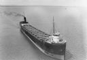
| Date: | 1935 |
|---|---|
| Description: | Aerial view of crew members standing and sitting on the deck of the ore boat Captain Thomas Wilson in Ashland harbor. |
If you didn't find the material you searched for, our Library Reference Staff can help.
Call our reference desk at 608-264-6535 or email us at: