 Filter: Categories of Wisconsin Historical Images
Filter: FULL_DATE of 1935
Filter: Type of Map or Atlas
Filter: Creator Name of Foster, Mary Stuart
Filter: Categories of Wisconsin Historical Images
Filter: FULL_DATE of 1935
Filter: Type of Map or Atlas
Filter: Creator Name of Foster, Mary Stuart

| Date: | 1935 |
|---|---|
| Description: | This map shows Wisconsin’s pinery region. Lake Superior, Lake Michigan, Lake Winnebago, Green Bay, the Wisconsin River, and the Mississippi River are label... |
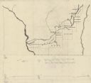
| Date: | 1935 |
|---|---|
| Description: | This manuscript map shows route of the early military road in Wisconsin from Green Bay (Fort Howard) through Portage (Fort Winnebago) to Fort Blue Mounds a... |
If you didn't find the material you searched for, our Library Reference Staff can help.
Call our reference desk at 608-264-6535 or email us at: