Filter: Categories of Wisconsin Historical Images
Filter: FULL_DATE of 1934
Filter: Subject of streets
Filter: Categories of Wisconsin Historical Images
Filter: FULL_DATE of 1934
Filter: Subject of streets
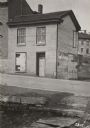
| Date: | 1934 |
|---|---|
| Description: | Exterior view of the Sherlock Hotel, 124 King Street at the corner of Doty Street. Snow is on the ground. |
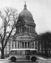
| Date: | 1934 |
|---|---|
| Description: | Bus of the Madison Railways Company parked in front of the Wisconsin State Capitol. |
| Date: | 1934 |
|---|---|
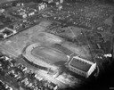
| Description: | Aerial view of Camp Randall Stadium and Field House on the University of Wisconsin-Madison campus. |

| Date: | 1934 |
|---|---|
| Description: | Fort Howard hospital, view from the southwest. |

| Date: | 1934 |
|---|---|
| Description: | Restored Fort Howard hospital, surgeon's quarters. |
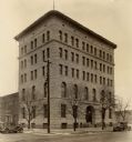
| Date: | 1934 |
|---|---|
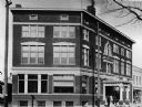
| Description: | The second YMCA building in Kenosha. It was used as a commercial structure at the time of the photograph. |

| Date: | 1934 |
|---|---|
| Description: | View from 121 East Gilman Street, of Annie S. Brown's Franklin car. In the background is the Governor's residence. |

| Date: | 1934 |
|---|---|
| Description: | Park Street looking north toward the University of Wisconsin campus. |

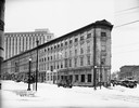
| Date: | 1934 |
|---|---|
| Description: | An exterior view of the Tenney Building, located at the corner of Pinckney and Main Streets on Capitol Square. Liggett's Drugstore occupies the first floor... |

| Date: | 1934 |
|---|---|
| Description: | Map showing the ward boundaries of Milwaukee. Each ward is numbered and boundary streets are labelled. The bottom right corner reads: "CITY ENGINEER'S DEPT... |

| Date: | 1934 |
|---|---|
| Description: | This map includes a street index. The map is oriented with the north toward the upper right. Includes handwritten annotations of the 1935 bus routes. |

| Date: | 1934 |
|---|---|
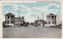
| Description: | Photographic postcard of an exterior view from the street of a stone church. Caption reads: "Grace Lutheran Church, Berlin, Wis." |

| Date: | 1934 |
|---|---|
| Description: | This map shows industrial points of interest in Superior. The top of the map reads: "Superior, Douglas County, Wisconsin, as this Industrial Tour map indic... |

| Date: | 1934 |
|---|---|
| Description: | This map is attached to a cover. Streets, points of interest, the Milwaukee River, and Lake Michigan are labeled. The bottom margin of the map includes a s... |
| Date: | 1934 |
|---|---|
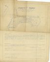
| Description: | Blue line print plat map that shows block numbers and dimensions, West Cole Street, Covall Street, Balden St., Parshall Parkway, and the location of the ci... |
| Date: | 1934 |
|---|---|
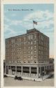
| Description: | Elevated view of an eight-story hotel on a downtown corner. Automobiles are parked along the curb. Caption reads: "Hotel Manitowoc, Manitowoc, Wis." |
| Date: | 1934 |
|---|---|
| Description: | View of a drawbridge in a business district. Stone structures are at each corner. Automobiles are in the street. Caption reads: "Washington Street Bridge, ... |
If you didn't find the material you searched for, our Library Reference Staff can help.
Call our reference desk at 608-264-6535 or email us at: