 Filter: Categories of Wisconsin Historical Images
Filter: FULL_DATE of 1934
Filter: Subject of land use, rural
Filter: Categories of Wisconsin Historical Images
Filter: FULL_DATE of 1934
Filter: Subject of land use, rural
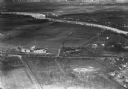
| Date: | 1934 |
|---|---|
| Description: | Aerial view of the Jones dairy farm, Fort Atkinson, in winter. The Rock River is in the background. |

| Date: | 1934 |
|---|---|
| Description: | Tree-lined dirt road curving along Madeline Island. |
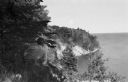
| Date: | 1934 |
|---|---|
| Description: | Man on Madeline Island cliff overlooking Lake Superior. |
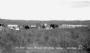
| Date: | 1934 |
|---|---|
| Description: | Elevated view over trees of the Civilian Conservation Corps (CCC) Camp, Moquah National Forest near Washburn, showing two buildings and about twenty-one te... |
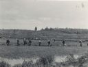
| Date: | 1934 |
|---|---|
| Description: | A team of cranberry harvesters work in a line across a flooded cranberry marsh. |

| Date: | 1934 |
|---|---|
| Description: | View down dirt road of field hands working to harvest cranberries in a flooded cranberry marsh, while men inspect newly harvested and crated cranberries. I... |
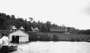
| Date: | 1934 |
|---|---|
| Description: | View of the White House Resort on Lake Gogebic. A man stands on a dock on the far left, while a wooden rowboat and boathouse are also visible in the foregr... |

| Date: | 1934 |
|---|---|
| Description: | This map shows the area as it appeared in 1848 and includes buildings, land use, and roads with distances to nearby locations. The upper right corner reads... |
If you didn't find the material you searched for, our Library Reference Staff can help.
Call our reference desk at 608-264-6535 or email us at: