 Filter: Categories of Wisconsin Historical Images
Filter: FULL_DATE of 1934
Filter: Subject of architecture
Filter: Type of Map or Atlas
Filter: Categories of Wisconsin Historical Images
Filter: FULL_DATE of 1934
Filter: Subject of architecture
Filter: Type of Map or Atlas

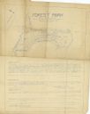
| Date: | 1934 |
|---|---|
| Description: | This 1934 map of Racine County, Wisconsin, shows the township and range grid, cities and villages, vegetation type, land use, roads, railroads, utilities, ... |

| Date: | 1934 |
|---|---|
| Description: | This map includes a street index. The map is oriented with the north toward the upper right. Includes handwritten annotations of the 1935 bus routes. |

| Date: | 1934 |
|---|---|
| Description: | This map is attached to a cover. Streets, points of interest, the Milwaukee River, and Lake Michigan are labeled. The bottom margin of the map includes a s... |
| Date: | 1934 |
|---|---|
| Description: | Blue line print plat map that shows block numbers and dimensions, West Cole Street, Covall Street, Balden St., Parshall Parkway, and the location of the ci... |
If you didn't find the material you searched for, our Library Reference Staff can help.
Call our reference desk at 608-264-6535 or email us at: