Filter: Categories of Wisconsin Historical Images
Filter: FULL_DATE of 1934
Filter: Subject of aerial photographs
Filter: Categories of Wisconsin Historical Images
Filter: FULL_DATE of 1934
Filter: Subject of aerial photographs
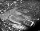
| Date: | 1934 |
|---|---|
| Description: | Aerial view of Camp Randall Stadium and Field House on the University of Wisconsin-Madison campus. |

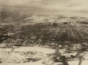
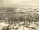
| Date: | 1934 |
|---|---|
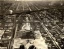
| Description: | Aerial view of Capitol and Lake Mendota and Lake Monona. |
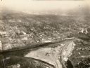
| Date: | 1934 |
|---|---|
| Description: | Aerial view of Janesville showing the river fill for the new sewerage disposal plant. |
| Date: | 1934 |
|---|---|
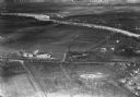
| Description: | Aerial view of the Jones dairy farm, Fort Atkinson, in winter. The Rock River is in the background. |
| Date: | 1934 |
|---|---|
| Description: | Aerial view of the play area for Roosevelt School. |
| Date: | 1934 |
|---|---|
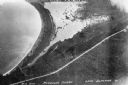
| Description: | Aerial view of Big Bay on Madeline Island. This area later became Big Bay State Park. |
| Date: | 1934 |
|---|---|
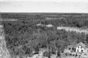
| Description: | Elevated view of the forest and the two-story Forest Ranger Station with two automobiles parked out front. |

| Date: | 1934 |
|---|---|
| Description: | Aerial view of Long Lake and its islands. A road leads out to the biggest island. Caption reads: "Woodland Park, Long Lake, Haugen, Wis. Aerial Photo by N.... |
If you didn't find the material you searched for, our Library Reference Staff can help.
Call our reference desk at 608-264-6535 or email us at: