 Filter: Categories of Wisconsin Historical Images
Filter: FULL_DATE of 1932
Filter: Subject of superior, lake
Filter: Categories of Wisconsin Historical Images
Filter: FULL_DATE of 1932
Filter: Subject of superior, lake
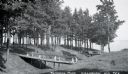
| Date: | 1932 |
|---|---|
| Description: | View of two wooden foot bridges in Memorial Park. In the background are the waters of Chequamegon Bay in Lake Superior. Picnic tables are among the trees. ... |

| Date: | 1932 |
|---|---|
| Description: | A map of Iron County, Wisconsin, shows towns and sections, lakes and streams, villages, railroads, roads, and La Point and Lac Du Flambeau Indian reservati... |
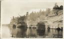
| Date: | 1932 |
|---|---|
| Description: | Lake view of Apostle Islands sandstone caves along the shores of Lake Superior. |

| Date: | 1932 |
|---|---|
| Description: | This map of Superior shows many points of interests including camping, fair grounds, docks, tourist attractions, lakes, roads, and waterways. |

| Date: | 1932 |
|---|---|
| Description: | This map shows automobile routes across Wisconsin and parts of Illinois, Michigan, Minnesota and Iowa. The Mississippi River, Lake Michigan, Lake Superior,... |

| Date: | 1932 |
|---|---|
| Description: | Text on front reads: "G.N. Elevator, Superior, Wis." The steel and reinforced concrete grain elevator was built by the Great Northern Railroad in Superior ... |
If you didn't find the material you searched for, our Library Reference Staff can help.
Call our reference desk at 608-264-6535 or email us at: