 Filter: Categories of Wisconsin Historical Images
Filter: FULL_DATE of 1931
Filter: Subject of transportation
Filter: Categories of Wisconsin Historical Images
Filter: FULL_DATE of 1931
Filter: Subject of transportation

| Date: | 1931 |
|---|---|
| Description: | Guest house with a sunroom in the front. |

| Date: | 1931 |
|---|---|
| Description: | Exterior view across street of the Modern Home Hotel in a residential neighborhood. There are large, enclosed porches on the first and second stories. A la... |

| Date: | 1931 |
|---|---|
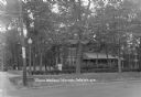
| Description: | View from side of road towards main building of Nettland's Roll Inn, with a service station, restaurant and registration office for their campsites. A grou... |

| Date: | 1931 |
|---|---|
| Description: | Three-quarter view from road of a guest house with a large porch. A large sign on the lawn in front advertises running water in the rooms and a rate of $1 ... |
| Date: | 1931 |
|---|---|
| Description: | View from street of Olson's Woodlawn Rooms, a large brick building with striped awnings over some of the windows on the first floor. A low stone wall is on... |
| Date: | 1931 |
|---|---|
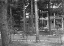
| Description: | View across stone-lined paths toward the annex, a three-story building with a porch and a balcony above. Pines trees are on the grounds, and there is a sma... |
| Date: | 1931 |
|---|---|
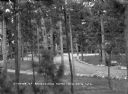
| Description: | Elevated view of the pines on the grounds of Ravenswood. Benches are set along a stone-lined path and an automobile is parked behind the trees on the right... |

| Date: | 1931 |
|---|---|
| Description: | View from street of the Hotel Van, which has a long porch facing the sidewalk, and exterior stairs leading to the balcony on the second floor. There are aw... |

| Date: | 1931 |
|---|---|
| Description: | Exterior view from road of the White House Hotel. There is a trellis with four columns at the sidewalk entrance that leads to a long porch with rocking cha... |

| Date: | 1931 |
|---|---|
| Description: | View from road of the guest cottages on both sides of the lawn. The property is bordered by white picket fences, and there is a row of stones in front alon... |

| Date: | 1931 |
|---|---|
| Description: | View of the Annex of the White House Hotel. There are three entrances on the porch. There is a porch swing on the left, and a bench is in the yard in front... |

| Date: | 1931 |
|---|---|
| Description: | This map shows streets and highways, street car and bus lines, railroads, depots, schools, wards, and points of interest. The map is oriented with the nort... |
| Date: | 1931 |
|---|---|
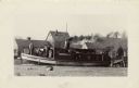
| Description: | The Frank Braeger is moored on the shore of Jones Island with steam issuing from the pipe, with the crew posing on the boat. In the background a man... |

| Date: | 1931 |
|---|---|
| Description: | Fishermen from the Frank Braeger fishing tugboat are standing for a group portrait in front of their fishing nets on Jones Island. |

| Date: | 1931 |
|---|---|
| Description: | View of the south end of a newly constructed barn. Edgar Krueger, with a team of two horses and the spreader, is coming out of the barn. A dog is standing ... |
| Date: | 1931 |
|---|---|
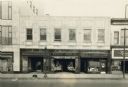
| Description: | View across street towards the Moseley Book Company, at 10 E. Mifflin Street. The storefront is below the offices of Central Life. Next door on the right a... |

| Date: | 1931 |
|---|---|
| Description: | This map shows the state trunk highway system and county trunk highways. This map show surface type on state and county trunk highways and the locations of... |

| Date: | 1931 |
|---|---|
| Description: | Road map of Wisconsin featuring the major freeways, highways, and cities. The front contains an index and a guide to the population of the various cities.... |

| Date: | 1931 |
|---|---|
| Description: | This map shows heavy industrial districts (yellow), commercial and light manufacturing districts (red), and residential districts (white) as well as a plat... |

| Date: | 1931 |
|---|---|
| Description: | This photocopy map shows lot and block numbers, some landownership and acreages, water flowage, and marshes. The map also shows Lake Menomin and Wilson Cr... |
If you didn't find the material you searched for, our Library Reference Staff can help.
Call our reference desk at 608-264-6535 or email us at: