 Filter: Categories of Wisconsin Historical Images
Filter: FULL_DATE of 1931
Filter: Subject of streams
Filter: Categories of Wisconsin Historical Images
Filter: FULL_DATE of 1931
Filter: Subject of streams

| Date: | 1931 |
|---|---|
| Description: | A topographical map from the U.S. Army Corp of Engineers showing the topography and man-made features in the Camp Williams area of the towns of Orange and ... |
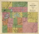
| Date: | 1931 |
|---|---|
| Description: | This 1931 map of Sawyer County, Wisconsin, shows the township and range system, towns, sections, cities and villages, railroads, highways and roads, and la... |
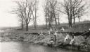
| Date: | 1931 |
|---|---|
| Description: | View across water towards a group of pupils from the Dyer School fishing from the banks of a stream "about a mile south of school." They are using long can... |
If you didn't find the material you searched for, our Library Reference Staff can help.
Call our reference desk at 608-264-6535 or email us at: