 Filter: Categories of Wisconsin Historical Images
Filter: FULL_DATE of 1931
Filter: Subject of railroads
Filter: Categories of Wisconsin Historical Images
Filter: FULL_DATE of 1931
Filter: Subject of railroads

| Date: | 1931 |
|---|---|
| Description: | A map of the village of Verona, Wisconsin. |
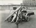
| Date: | 1931 |
|---|---|
| Description: | McCormick-Deering corn binder parked outside a Chicago factory, most likely the McCormick Works. Decals and/or stencils are on the machine. |

| Date: | 1931 |
|---|---|
| Description: | This map of south central Wisconsin shows lakes, rivers, cities, villages, highways and roads, railroads, Indian mounds, and points of scenic and historic ... |
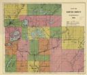
| Date: | 1931 |
|---|---|
| Description: | This 1931 map of Sawyer County, Wisconsin, shows the township and range system, towns, sections, cities and villages, railroads, highways and roads, and la... |

| Date: | 1931 |
|---|---|
| Description: | Relief shown by contours and spot heights. Maps shows United States, state, county and local highways and roads, schools, North Bend, creeks, lakes, rivers... |

| Date: | 1931 |
|---|---|
| Description: | This map of Ashland shows roads, railroads, and local businesses. The map reads: "Showing streets and roads open to the public Oct. 1, 1931." Included on t... |

| Date: | 1931 |
|---|---|
| Description: | This map shows streets and highways, street car and bus lines, railroads, depots, schools, wards, and points of interest. The map is oriented with the nort... |
If you didn't find the material you searched for, our Library Reference Staff can help.
Call our reference desk at 608-264-6535 or email us at: