 Filter: Categories of Wisconsin Historical Images
Filter: FULL_DATE of 1931
Filter: Subject of military art and science
Filter: Categories of Wisconsin Historical Images
Filter: FULL_DATE of 1931
Filter: Subject of military art and science
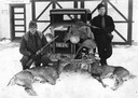
| Date: | 1931 |
|---|---|
| Description: | Two hunters with rifles pose in the snow by a car with three deer carcasses. |
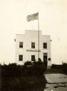
| Date: | 1931 |
|---|---|
| Description: | View of men standing on the lawn in front of the Wisconsin Territorial Capitol. They are standing near the monument of a shell of the Civil War period, rec... |
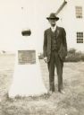
| Date: | 1931 |
|---|---|
| Description: | A shell of the Civil War period, recovered from the Mississippi River near Vicksburg, Mississippi, and presented to the First Capitol State Park by the GAR... |
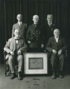
| Date: | 1931 |
|---|---|
| Description: | Portrait of the five surviving members of the Grand Army of the Republic, John H. Williams, Post No. 4. Standing from left to right around the framed chart... |

| Date: | 1931 |
|---|---|
| Description: | This U.S. Geological Survey map of Wisconsin shows counties, cities and villages, lighthouses, Indian reservations, military reservations, and bird and gam... |

| Date: | 1931 |
|---|---|
| Description: | A topographical map from the U.S. Army Corp of Engineers showing the topography and man-made features in the Camp Williams area of the towns of Orange and ... |
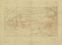
| Date: | 1931 |
|---|---|
| Description: | Top of the map reads: "SPECIAL MILITARY MAP 2626:2757:/27:2080:" and "Advance sheet, subject to correction." Bottom right of the map reads: "South Range gu... |
If you didn't find the material you searched for, our Library Reference Staff can help.
Call our reference desk at 608-264-6535 or email us at: