 Filter: Categories of Wisconsin Historical Images
Filter: FULL_DATE of 1931
Filter: Subject of cemeteries
Filter: Categories of Wisconsin Historical Images
Filter: FULL_DATE of 1931
Filter: Subject of cemeteries

| Date: | 1931 |
|---|---|
| Description: | Jewish cemetery in Prague taken by one of a group of visiting Rotarians. |
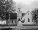
| Date: | 1931 |
|---|---|
| Description: | Exterior view from across street of the church. It has a bell steeple, stained glass windows, double french doors with an archway, and a wall gable facade.... |

| Date: | 1931 |
|---|---|
| Description: | Relief shown by contours and spot heights. Maps shows United States, state, county and local highways and roads, schools, North Bend, creeks, lakes, rivers... |

| Date: | 1931 |
|---|---|
| Description: | Map shows street map with wards numbered, the Fox River, railroads, playgrounds, cemeteries, and schools. The map also includes a manuscript annotation ind... |

| Date: | 1931 |
|---|---|
| Description: | This map shows streets and highways, street car and bus lines, railroads, depots, schools, wards, and points of interest. The map is oriented with the nort... |
If you didn't find the material you searched for, our Library Reference Staff can help.
Call our reference desk at 608-264-6535 or email us at: