 Filter: Categories of Wisconsin Historical Images
Filter: FULL_DATE of 1930
Filter: Year of 1900-1999
Filter: Creator Name of Kapitz, George V.
Filter: Categories of Wisconsin Historical Images
Filter: FULL_DATE of 1930
Filter: Year of 1900-1999
Filter: Creator Name of Kapitz, George V.
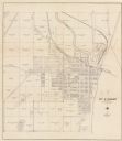
| Date: | 1930 |
|---|---|
| Description: | This cadastral map shows ownership and acreage of lots. Streets, the Kewaunee River, and Lake Michigan are labeled. |
If you didn't find the material you searched for, our Library Reference Staff can help.
Call our reference desk at 608-264-6535 or email us at: