Filter: Categories of Wisconsin Historical Images
Filter: FULL_DATE of 1930
Filter: Subject of cities and towns
Filter: County of Iowa
Filter: Categories of Wisconsin Historical Images
Filter: FULL_DATE of 1930
Filter: Subject of cities and towns
Filter: County of Iowa
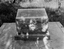
| Date: | 1930 |
|---|---|
| Description: | Historical marker on the site of Henry Dodge's homestead. Dodge was the first territorial governor of Wisconsin. |

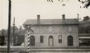
| Date: | 1930 |
|---|---|
| Description: | Exterior view of the Iowa County Court House, with cars parked at the curb in front. |

| Date: | 1930 |
|---|---|
| Description: | The home of a Cornish miner in Mineral Point. Houses are on a hill in the background. |

| Date: | 1930 |
|---|---|
| Description: | A Mineral Point high school used through 1904. |

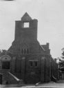
| Date: | 1930 |
|---|---|
| Description: | The Odd Fellows Hall, built in 1837-1838, was the first to be built west of the Allegheny Mountains. The cornerstones were laid by Thomas Widley. |

| Date: | 1930 |
|---|---|
| Description: | The Odd Fellows Hall, built in 1838, was the first to be built west of the Allegheny Mountains. The cornerstones were laid by P.G. Sire Thomas Widley, foun... |

| Date: | 1930 |
|---|---|
| Description: | The home of Moses Strong, a prominent attorney, politician, speculator and land agent who moved to Wisconsin Territory and settled in Mineral Point in 1836... |
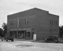
| Date: | 1930 |
|---|---|
| Description: | View from street of exterior of the Cobb Hotel and Cafe. A truck and car are parked outside the building. |
| Date: | 1930 |
|---|---|
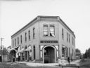
| Description: | Exterior of the wedge-shaped Hicks Hotel. Lovelace general store is housed on the left side of the building. There are children in the street and on the si... |
| Date: | 1930 |
|---|---|
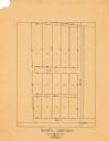
| Description: | This map is pen and pencil on paper and shows local streets, lots by number, and section divisions. |
If you didn't find the material you searched for, our Library Reference Staff can help.
Call our reference desk at 608-264-6535 or email us at: