 Filter: Categories of Wisconsin Historical Images
Filter: FULL_DATE of 1930
Filter: Subject of cities and towns
Filter: Type of Map or Atlas
Filter: Categories of Wisconsin Historical Images
Filter: FULL_DATE of 1930
Filter: Subject of cities and towns
Filter: Type of Map or Atlas

| Date: | 1930 |
|---|---|
| Description: | Pen and ink map on paper of Wisconsin and northern Illinois showing stagecoach routes (marked in red) that traveled between Lake Michigan and the Mississip... |

| Date: | 1930 |
|---|---|
| Description: | This map shows Indian trails through Wisconsin counties. The trail are in red ink. Lake Michigan, Green Bay, Lake Superior, and the Wisconsin River are lab... |

| Date: | 1930 |
|---|---|
| Description: | This road map of Chippewa County, Wisconsin, dates to around 1930. It shows the township and range grid, towns, sections, cities and villages, railroads, l... |

| Date: | 1930 |
|---|---|
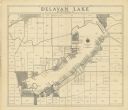
| Description: | Shows roads, fire stations, golf course, and accommodations around Delavan Lake. "The drive around the lake is divided into zones from 0 to 900 as shown. P... |
| Date: | 1930 |
|---|---|
| Description: | Map shows prairie, oak, maple, oak and maple, marsh conifer, maple and beech, and grass and sedge. |

| Date: | 1930 |
|---|---|
| Description: | This map of Waukesha County, Wisconsin, from the 1930s shows the township and range grid, towns, sections, cities and villages, highways and roads, railroa... |

| Date: | 1930 |
|---|---|
| Description: | This pictorial map from the first half of the 20th century shows the landmarks, highways, rail lines, and cities and villages in the vicinity of the Wiscon... |
| Date: | 1930 |
|---|---|
| Description: | This early-mid 20th century map of Brown County, Wisconsin, shows the township and range grid, towns, sections, cities and villages, land owners and acreag... |
| Date: | 1930 |
|---|---|
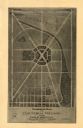
| Description: | Shows points of historic interest in Dane County; includes explanation of historical points of interest and corresponding symbols. "Map of historic sites i... |
| Date: | 1930 |
|---|---|
| Description: | Shows land ownership by name, roads, and highways. Includes manuscript annotations. |

| Date: | 1930 |
|---|---|
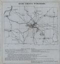
| Description: | Shows county system of roads which are surfaced, well graded, common, or unimproved, town roads, state trunk highways, town and village boundaries, schools... |

| Date: | 1930 |
|---|---|
| Description: | Shows county system of roads which are surfaced, well graded, common, or unimproved, town roads, state trunk highways, town and village boundaries, schools... |

| Date: | 1930 |
|---|---|
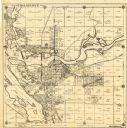
| Description: | Lower left hand corner reads: "Compliment of the Madison Association of Commerce MADISON The Four Lake City WISCONSIN." Around the perimeter of the map is ... |

| Date: | 1930 |
|---|---|
| Description: | Indexed map of Madison. Streets, lakes, and points of interest are labelled. Around the edges of the map are the indexed street names. |

| Date: | 1930 |
|---|---|
| Description: | Map of Ripon, Wisconsin. In the lower left hand corner is a list of points of interest that correspond with numbers on the map. Streets and Mill Pond are l... |
| Date: | 1930 |
|---|---|
| Description: | This map of Tomahawk shows landownership, an original plat of the city, various plat additions, roads, and railroads. The map includes annotations of road ... |
| Date: | 1930 |
|---|---|
| Description: | This map of Granville shows local streets, local businesses, and industrial areas. Some streets are labeled: "Lovers Lane Road," "Granville Road," and "Bro... |

| Date: | 1930 |
|---|---|
| Description: | This map of Madison is 7 maps showing the city between 1885 and 1930. Each map has its own annotations of population growth, neighborhoods, and other cha... |

| Date: | 1930 |
|---|---|
| Description: | This map shows the western side of Madison, from Nakoma to the capitol. The map is oriented with north to upper right and the scale is indicated by quarter... |
If you didn't find the material you searched for, our Library Reference Staff can help.
Call our reference desk at 608-264-6535 or email us at:
