 Filter: Categories of Wisconsin Historical Images
Filter: FULL_DATE of 1930
Filter: County of Door
Filter: Categories of Wisconsin Historical Images
Filter: FULL_DATE of 1930
Filter: County of Door
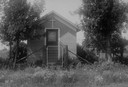
| Date: | 1930 |
|---|---|
| Description: | One-room building out in a field, with a cross above the doorway. Trees stand to the left and right of the shrine, and a fence and gate surround it. |
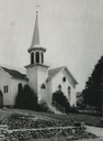
| Date: | 1930 |
|---|---|
| Description: | Exterior view of the front of a Moravian Church with a steeple. |
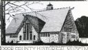
| Date: | 1930 |
|---|---|
| Description: | Drawing of the museum. Caption reads: "Door County Historical Museum." Text at bottom right of drawing: "William J. Bernhard, Architect." |
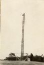
| Date: | 1930 |
|---|---|
| Description: | A totem pole erected in 1927 in honor of the aboriginal inhabitants of Wisconsin. Potawatomi chief Simon Onanguisse Kahquados (1851-November 27, 1930), an ... |

| Date: | 1930 |
|---|---|
| Description: | Aerial view, looking northeast, across Mud Lake with North Bay in the background, showing cultivated fields and wooded land. |

| Date: | 1930 |
|---|---|
| Description: | Aerial view looking north across the wooded peninsula separating Europe Bay (top) from Newport Bay. This area is now part of Newport State Park. |

| Date: | 1930 |
|---|---|
| Description: | Aerial view of the northern tip of the Door Peninsula, looking north. Europe Lake is in the center, with Europe Bay to the right. Plum Island and Washingto... |

| Date: | 1930 |
|---|---|
| Description: | Aerial view looking northeast, with Rowley's Bay in the foreground. Europe Lake is to the left, with Europe Bay and Newport Bay separated by a narrow peni... |

| Date: | 1930 |
|---|---|
| Description: | Aerial view over northern Door County, looking northeast across Europe Lake and Europe Bay toward Plum and Washington Islands. Farm fields and orchards con... |

| Date: | 1930 |
|---|---|
| Description: | Aerial view from over Moonlight Bay, looking east across Bues Point to Spike Horn Bay and Cana Island. The Cana Island Lighthouse is seen as a ship passes ... |

| Date: | 1930 |
|---|---|
| Description: | Aerial view, looking north, across the beach and pier on Europe Bay to Europe Lake and beyond to Washington Island. The land south (to the right) of Europe... |

| Date: | 1930 |
|---|---|
| Description: | "Issued by Door County Chamber of Commerce." Shows federal system highways, state highways, county trunk highways, country roads, and parks. Includes direc... |

| Date: | 1930 |
|---|---|
| Description: | Text on front reads: "Orchard Scene, Cherry Trees in Bloom, Door County, Wis." Elevated view of a cherry orchard with farm buildings. There are wooded hill... |

| Date: | 1930 |
|---|---|
| Description: | Text on front reads: "Cedar Street, Sturgeon Bay, Wis." Storefronts on a street with automobiles parked diagonally at the curb. Some pedestrians can be see... |
If you didn't find the material you searched for, our Library Reference Staff can help.
Call our reference desk at 608-264-6535 or email us at: