 Filter: Categories of Wisconsin Historical Images
Filter: FULL_DATE of 1930
Filter: Community of Madison
Filter: Categories of Wisconsin Historical Images
Filter: FULL_DATE of 1930
Filter: Community of Madison
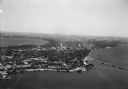
| Date: | 1930 |
|---|---|
| Description: | Aerial view of the Isthmus and the city of Madison including the downtown business district, the Wisconsin State Capitol, both Lake Mendota and Lake Monona... |

| Date: | 1930 |
|---|---|
| Description: | Aerial view of the University of Wisconsin-Madison campus, the State Historical Society of Wisconsin building, Lake Mendota, residential areas and the surr... |
| Date: | 1930 |
|---|---|
| Description: | Aerial view of the city and the Isthmus, the Wisconsin State Capitol, the downtown business district, and both Lake Mendota and Lake Monona. |
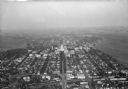
| Date: | 1930 |
|---|---|
| Description: | Aerial view of the city, including the Isthmus, the Wisconsin State Capitol, the downtown business district, Lake Mendota, and Lake Monona. |

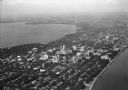
| Date: | 1930 |
|---|---|
| Description: | Aerial view of the Wisconsin State Capitol, the surrounding businesses, and Lake Monona. |

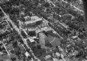
| Date: | 1930 |
|---|---|
| Description: | Aerial view of the Wisconsin State Capitol and the surrounding businesses. |

| Date: | 1930 |
|---|---|
| Description: | Aerial view of the Wisconsin State Capitol and the surrounding businesses. |

| Date: | 1930 |
|---|---|
| Description: | Aerial view of the city with horizon in the far distance. Includes the Wisconsin State Capitol, businesses, Lake Monona, and the surrounding neighborhoods. |

| Date: | 1930 |
|---|---|
| Description: | Aerial view of the University of Wisconsin-Madison campus including Camp Randall Stadium, the Wisconsin State Capitol, and both Lake Mendota and Lake Monon... |

| Date: | 1930 |
|---|---|
| Description: | Aerial view of Tenney Park, including the lagoon, residences surrounding the park, and the shoreline of Lake Mendota on bottom left. |

| Date: | 1930 |
|---|---|
| Description: | Aerial view of Hoyt Park including the surrounding neighborhoods. Resurrection Cemetery can be seen at the upper right of the image. |
| Date: | 1930 |
|---|---|
| Description: | Aerial view of Madison General Hospital (currently Meriter Hospital), located on South Park Street, and the surrounding residential neighborhoods. |

| Date: | 1930 |
|---|---|
| Description: | Aerial view of the University of Wisconsin-Madison Arboretum including a portion of Lake Wingra and surrounding residential neighborhoods. |

| Date: | 1930 |
|---|---|
| Description: | Aerial view of near west side, including West High School, the Forest Products Laboratory, Lake Mendota, and Picnic Point. |

| Date: | 1930 |
|---|---|
| Description: | Aerial view of Pennco Field (Royal Airport), and Lake Monona near the city limits. A crowd is gathered at the airport to watch an air show. |

| Date: | 1930 |
|---|---|
| Description: | Aerial view of the University of Wisconsin-Madison Arboretum including the surrounding residential neighborhoods. |

| Date: | 1930 |
|---|---|
| Description: | Aerial view of the Pennco Field (Royal Airport), including the hanger and airplanes on the ground. Lake Monona, the Wisconsin State Capitol, and the Madiso... |

| Date: | 1930 |
|---|---|
| Description: | Aerial view of the Pennco Field (Royal Airport) hanger surrounded by spectators gathered for an air show. Biplanes are parked on the grounds of the airpor... |

| Date: | 1930 |
|---|---|
| Description: | Aerial view of biplanes at the Pennco Field (Royal Airport), probably for an air show. Lake Monona is in the background. |
If you didn't find the material you searched for, our Library Reference Staff can help.
Call our reference desk at 608-264-6535 or email us at:
