 Filter: Categories of Wisconsin Historical Images
Filter: FULL_DATE of 1930
Filter: Community of Madison
Filter: Categories of Wisconsin Historical Images
Filter: FULL_DATE of 1930
Filter: Community of Madison

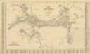
| Date: | 1930 |
|---|---|
| Description: | Lower left hand corner reads: "Compliment of the Madison Association of Commerce MADISON The Four Lake City WISCONSIN." Around the perimeter of the map is ... |

| Date: | 1930 |
|---|---|
| Description: | Indexed map of Madison. Streets, lakes, and points of interest are labelled. Around the edges of the map are the indexed street names. |
| Date: | 1930 |
|---|---|
| Description: | This map is indexed with the north oriented toward the upper right. The map includes a collection manuscript annotations. |
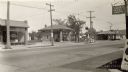
| Date: | 1930 |
|---|---|
| Description: | Businesses located near the intersection of Park and Lakeside Streets, before Park Street was widened. Identified from left, Madison Do-Nut Kitchen, Valvol... |
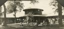
| Date: | 1930 |
|---|---|
| Description: | View across lawn towards a large shelter at Bernard's Park filled with people. Other people relax at picnic tables in under trees in the foreground. |
| Date: | 1930 |
|---|---|
| Description: | A man dressed in a white uniform, hat and apron with a dark necktie poses on the steps to Nature's Own Health Foods at 501 West Olin Avenue. He is displayi... |
| Date: | 1930 |
|---|---|
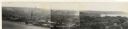
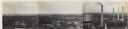
| Description: | Panoramic elevated view to the west from the Capitol Square. In the section on the left, (left to right), are the University of Wisconsin Field House, Luth... |
| Date: | 1930 |
|---|---|
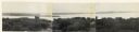
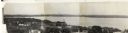
| Description: | Panoramic elevated view to the northwest from the Capitol Square. |
| Date: | 1930 |
|---|---|
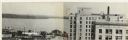
| Description: | Panoramic elevated view to the north from the Capitol Square. |
| Date: | 1930 |
|---|---|
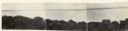
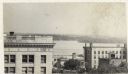
| Description: | Panoramic elevated view to the north from the Capitol Square. |
| Date: | 1930 |
|---|---|
| Description: | Panoramic elevated view to the northeast from the Capitol Square. |
| Date: | 1930 |
|---|---|
| Description: | Panoramic elevated view to the east from the Capitol Square. |
| Date: | 1930 |
|---|---|
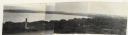
| Description: | Panoramic elevated view to the southeast from the Capitol Square. The Tenney Building appears behind the original first National Bank that was demolished t... |
| Date: | 1930 |
|---|---|
| Description: | Elevated view to the south from the Capitol Square. The large building on the left is the original first National Bank that was demolished to make way for ... |

| Date: | 1930 |
|---|---|
| Description: | This map features a legend of highways, railroads, parks, and service stations. The cover and inside of the map features pictures of attractions in Madison... |

| Date: | 1930 |
|---|---|
| Description: | This map of Madison is 7 maps showing the city between 1885 and 1930. Each map has its own annotations of population growth, neighborhoods, and other cha... |

| Date: | 1930 |
|---|---|
| Description: | This map shows the western side of Madison, from Nakoma to the capitol. The map is oriented with north to upper right and the scale is indicated by quarter... |

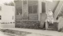
| Date: | 1930 |
|---|---|
| Description: | View across lawn towards the T.C. Richmond House, which was located on the south side of Lakeside Street, between 505 and 605 W. Lakeside Street. The house... |

| Date: | 1930 |
|---|---|
| Description: | Madison Police Chief Frank Trostle. Trostle served as police chief from 1925-1930. |
If you didn't find the material you searched for, our Library Reference Staff can help.
Call our reference desk at 608-264-6535 or email us at:
