 Filter: Categories of Wisconsin Historical Images
Filter: FULL_DATE of 1930
Filter: Type of Map or Atlas
Filter: Subject of roads
Filter: Categories of Wisconsin Historical Images
Filter: FULL_DATE of 1930
Filter: Type of Map or Atlas
Filter: Subject of roads

| Date: | 1930 |
|---|---|
| Description: | Pen and ink map on paper of Wisconsin and northern Illinois showing stagecoach routes (marked in red) that traveled between Lake Michigan and the Mississip... |

| Date: | 1930 |
|---|---|
| Description: | This road map of Chippewa County, Wisconsin, dates to around 1930. It shows the township and range grid, towns, sections, cities and villages, railroads, l... |

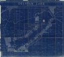
| Date: | 1930 |
|---|---|
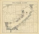
| Description: | Shows roads, fire stations, golf course, and accommodations around Delavan Lake. "The drive around the lake is divided into zones from 0 to 900 as shown. P... |

| Date: | 1930 |
|---|---|
| Description: | This manuscript map, likely drawn in the 1930s, shows Fox Lake, in Dodge County, Wisconsin, and the roads and resorts in the vicinity. |

| Date: | 1930 |
|---|---|
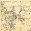
| Description: | This map of Waukesha County, Wisconsin, from the 1930s shows the township and range grid, towns, sections, cities and villages, highways and roads, railroa... |

| Date: | 1930 |
|---|---|
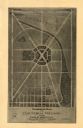
| Description: | This pictorial map from the first half of the 20th century shows the landmarks, highways, rail lines, and cities and villages in the vicinity of the Wiscon... |
| Date: | 1930 |
|---|---|
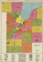
| Description: | This early-mid 20th century map of Brown County, Wisconsin, shows the township and range grid, towns, sections, cities and villages, land owners and acreag... |
| Date: | 1930 |
|---|---|
| Description: | Shows land ownership by name, roads, and highways. Includes manuscript annotations. |

| Date: | 1930 |
|---|---|
| Description: | "Issued by Door County Chamber of Commerce." Shows federal system highways, state highways, county trunk highways, country roads, and parks. Includes direc... |

| Date: | 1930 |
|---|---|
| Description: | Shows county system of roads which are surfaced, well graded, common, or unimproved, town roads, state trunk highways, town and village boundaries, schools... |

| Date: | 1930 |
|---|---|
| Description: | Shows county system of roads which are surfaced, well graded, common, or unimproved, town roads, state trunk highways, town and village boundaries, schools... |
| Date: | 1930 |
|---|---|
| Description: | This map of Tomahawk shows landownership, an original plat of the city, various plat additions, roads, and railroads. The map includes annotations of road ... |
| Date: | 1930 |
|---|---|
| Description: | This map of Granville shows local streets, local businesses, and industrial areas. Some streets are labeled: "Lovers Lane Road," "Granville Road," and "Bro... |

| Date: | 1930 |
|---|---|
| Description: | This map features a legend of highways, railroads, parks, and service stations. The cover and inside of the map features pictures of attractions in Madison... |

| Date: | 1930 |
|---|---|
| Description: | This map shows the state trunk highway system and county trunk highways. This map show surface type on state and county trunk highways and the locations of... |
| Date: | 1930 |
|---|---|
| Description: | This blue line print shows land ownership by name, roads, and highways. The map includes manuscript annotations in pencil. |

| Date: | 1930 |
|---|---|
| Description: | This map shows schools, school districts, town sections, highways, railroads, and hydrography of the area around Hurley. The right margin includes and expl... |

| Date: | 1930 |
|---|---|
| Description: | This map shows surface types on the highways including: concrete, bit, mat, gravels, shales, and unsurfaced. County boundaries, cities, rivers, roads, high... |

| Date: | 1930 |
|---|---|
| Description: | This map shows county boundaries, roads, cities, highways, points of interest, and the locations of Standard Oil Company Service Stations. Included are por... |
If you didn't find the material you searched for, our Library Reference Staff can help.
Call our reference desk at 608-264-6535 or email us at:
