 Filter: Categories of Wisconsin Historical Images
Filter: FULL_DATE of 1930
Filter: Type of Map or Atlas
Filter: County of Brown
Filter: Categories of Wisconsin Historical Images
Filter: FULL_DATE of 1930
Filter: Type of Map or Atlas
Filter: County of Brown

| Date: | 1930 |
|---|---|
| Description: | These 40 hand-drawn maps depict the survey townships in Oneida County, Wisconsin, on printed township grids. Lakes, rivers, and waterfront properties are d... |
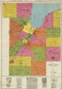
| Date: | 1930 |
|---|---|
| Description: | This early-mid 20th century map of Brown County, Wisconsin, shows the township and range grid, towns, sections, cities and villages, land owners and acreag... |

| Date: | 1930 |
|---|---|
| Description: | This map shows a plat of the town, local streets, railroads, creeks, part of Fox River, and part of the bay of Green Bay. The location of the original fort... |
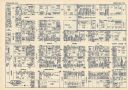
| Date: | 1930 |
|---|---|
| Description: | This map shows local streets, blocks, lots, local businesses by name, and bus stops. On the back of the map is text, illustrations, and aerial views. |
If you didn't find the material you searched for, our Library Reference Staff can help.
Call our reference desk at 608-264-6535 or email us at: