Filter: Categories of Wisconsin Historical Images
Filter: FULL_DATE of 1929
Filter: Subject of school buildings
Filter: Categories of Wisconsin Historical Images
Filter: FULL_DATE of 1929
Filter: Subject of school buildings
| Date: | 1929 |
|---|---|
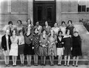
| Description: | Group of stylishly dressed girls from a Wisconsin high school posing outdoors. |
| Date: | 1929 |
|---|---|
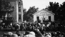
| Description: | 75th anniversary celebration of the birth of the Republican Party at Ripon. Governor Walter J. Kohler, Sr., stands on the podium in front of the Little Whi... |
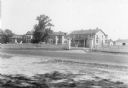
| Date: | 1929 |
|---|---|
| Description: | Keshena Indian School, an Indian Government School building. |
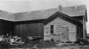
| Date: | 1929 |
|---|---|
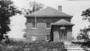
| Description: | The Westport School attended by Ella Wheeler. It is now used as a tool shed. A large barn is behind the smaller building. |
| Date: | 1929 |
|---|---|
| Description: | The Government Indian School in Keshena. |
| Date: | 1929 |
|---|---|
| Description: | The U.S. Department of the Interior, Keshena Indian School. |
| Date: | 1929 |
|---|---|
| Description: | Indian boarding school at Lac du Flambeau Ojibwe Reservation. Children are in front of the building, and in the side yard. |
| Date: | 1929 |
|---|---|
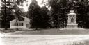
| Description: | School and war memorial on Washington Island. |

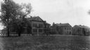
| Date: | 1929 |
|---|---|
| Description: | Side view through trees of Wisconsin High School. |

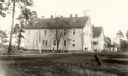
| Date: | 1929 |
|---|---|
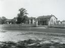
| Description: | Exterior view of the public school. The school building features two stories, a bell tower, and a porch. A car is parked by the entrance. There is a swing ... |

| Date: | 1929 |
|---|---|
| Description: | View across street of the three-story grade school. |

| Date: | 1929 |
|---|---|
| Description: | This 1929 topographic map of Trempealeau County, Wisconsin, shows the topography, lakes, streams and wetlands, township and range grid, sections, cities an... |

| Date: | 1929 |
|---|---|
| Description: | Map shows townships and sections, landownership and acreages, roads, schools, school districts, churches, and cemeteries. Includes index of acreage tracts. |

| Date: | 1929 |
|---|---|
| Description: | View of front of the public school, a two-story brick building with a cupola and flagpole over the bell. A cornfield and bluff are in the background. |
| Date: | 1929 |
|---|---|
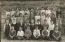
| Description: | Students pose outdoors in front of a stone building at Saint Raphael's School. David O'Dea is seated cross-legged on the ground, 3rd from the right. He is ... |

| Date: | 1929 |
|---|---|
| Description: | This is a blue line print map that shows local streets, railroads, local businesses, schools, parks, cemeteries, the airport, the state capitol, the Univer... |
If you didn't find the material you searched for, our Library Reference Staff can help.
Call our reference desk at 608-264-6535 or email us at: