Filter: Categories of Wisconsin Historical Images
Filter: FULL_DATE of 1929
Filter: Subject of rivers
Filter: Categories of Wisconsin Historical Images
Filter: FULL_DATE of 1929
Filter: Subject of rivers
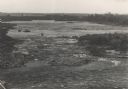
| Date: | 1929 |
|---|---|
| Description: | The gorge of the Bad River below Brownstone Falls. |
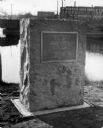
| Date: | 1929 |
|---|---|
| Description: | View of the George Stevens marker with the Wisconsin Auto Supply Company in the background and the Wisconsin River. |

| Date: | 1929 |
|---|---|
| Description: | Panoramic view of Horlick's Malted Milk Corporation buildings. |
| Date: | 1929 |
|---|---|
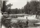
| Description: | Group of people at Bear Trap Falls in the Wolf River near Keshena. People are standing on the shoreline on the left near a sign for the falls. A man is sta... |
| Date: | 1929 |
|---|---|
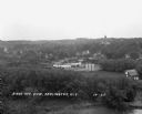
| Description: | Elevated view of town looking down a hill. In the foreground is a river with trees along the bank. On the other side of the river is a factory with industr... |
| Date: | 1929 |
|---|---|
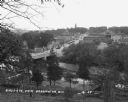
| Description: | View down tree-lined hill over the Pecatonica River. The bridge connects River Street to Main Street. Storefronts line the street, and the Lafayette County... |
| Date: | 1929 |
|---|---|
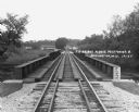
| Description: | View down the railroad tracks across the bridge. On the far side are barns and industrial buildings among trees. |

| Date: | 1929 |
|---|---|
| Description: | "Compliments of the Douglas County Highway Department"--Top margin. Shows state-trunk highways, county highways, town roads, trails, boundaries, and concr... |

| Date: | 1929 |
|---|---|
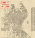
| Description: | This map is oriented with north to the upper right. Includes index of retailers and buildings, with some advertisements in margins. |

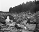
| Date: | 1929 |
|---|---|
| Description: | View looking down at the dam on the Kickapoo River. Houses are on the far side of the river, and chimneys are blowing heavy smoke. In the far background is... |

| Date: | 1929 |
|---|---|
| Description: | Ho-Chunk women perform the Swan Dance. There is a group of men sitting in a circle next to them. |
| Date: | 1929 |
|---|---|
| Description: | This map shows streets, railroads, parks, cemeteries, and a proposed harbor. The top margin includes an advertisement for Delco Motor Oil and the right mar... |
| Date: | 1929 |
|---|---|
| Description: | This map shows county boundaries, roads, highways, cities, rivers, lakes, and points of interest. Caption reads: "Compliments of Hotel Warren, Baraboo, Wis... |

| Date: | 1929 |
|---|---|
| Description: | This map with north oriented to the upper left shows military forts, Indian villages, settler's houses with surnames, trading houses, lodges and encampment... |

| Date: | 1929 |
|---|---|
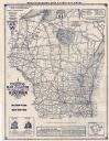
| Description: | This map of the entire state includes portions of Illinois, Iowa, Michigan, and Minnesota. The map shows U.S., state, and county highways, roads, campsites... |

| Date: | 1929 |
|---|---|
| Description: | This map shows the entire state of Wisconsin and Minnesota and portions of Illinois and Iowa. Counties, cities, highways, lakes, and rivers are labeled. Ro... |
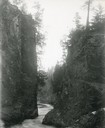
| Date: | 1929 |
|---|---|
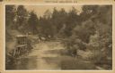
| Description: | Text on front reads: "Trout Falls, Near Sparta, Wis." Elevated view of river. On the left bank at the base of the falls is an open-sided stilt structure wi... |
If you didn't find the material you searched for, our Library Reference Staff can help.
Call our reference desk at 608-264-6535 or email us at: