 Filter: Categories of Wisconsin Historical Images
Filter: FULL_DATE of 1929
Filter: Subject of lakes
Filter: Categories of Wisconsin Historical Images
Filter: FULL_DATE of 1929
Filter: Subject of lakes

| Date: | 1929 |
|---|---|
| Description: | Bird's-eye map of the University of Wisconsin-Madison on Lake Mendota. Black and white drawing with named streets and numbered buildings without location ... |

| Date: | 1929 |
|---|---|
| Description: | View of the College of Agriculture on the University of Wisconsin Madison campus as seen from the tower of the First Congressional Church. |

| Date: | 1929 |
|---|---|
| Description: | View from water of the Hydraulic Engineering Building on the University of Wisconsin-Madison campus. The building is located on the edge of Lake Mendota an... |

| Date: | 1929 |
|---|---|
| Description: | Terrace at the Memorial Union on the University of Wisconsin-Madison campus. Pedestrians are walking along the shoreline of Lake Mendota. The University of... |

| Date: | 1929 |
|---|---|
| Description: | View from the tower of the Congregational Church towards Lake Mendota and the University of Wisconsin-Madison campus. Picnic Point is in the center backgro... |

| Date: | 1929 |
|---|---|
| Description: | Elevated panoramic view towards the northeast from the tower of the Congregational Church of the University of Wisconsin-Madison campus, with Lake Mendota ... |
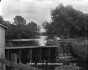
| Date: | 1929 |
|---|---|
| Description: | Elevated view of a man-made dam. Water pours from the dam into a reservoir creating a waterfall. |

| Date: | 1929 |
|---|---|
| Description: | View from the shore looking at Lake Mendota and lake houses on a nearby shore. A rowboat is chained to a tree on the shore. |

| Date: | 1929 |
|---|---|
| Description: | This 1929 topographic map of Trempealeau County, Wisconsin, shows the topography, lakes, streams and wetlands, township and range grid, sections, cities an... |

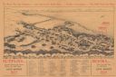
| Date: | 1929 |
|---|---|
| Description: | This map is oriented with north to the upper right. Includes index of retailers and buildings, with some advertisements in margins. |

| Date: | 1929 |
|---|---|
| Description: | Shows fraternities, sororities, major rooming houses, private and university buildings, and university property. Oriented with north slightly to the right. |
| Date: | 1929 |
|---|---|
| Description: | Bird’s-eye view map. Top of map reads: "To Show You the Campus ... and Gatewood's Book Store ... Further Instructions ... You Will Need No More". Bottom le... |

| Date: | 1929 |
|---|---|
| Description: | A view across water of Lake Kegonsa's shoreline with cottages, docks and trees. A boy is in a rowboat near a boathouse in the foreground. |

| Date: | 1929 |
|---|---|
| Description: | This is a blue line print map that shows local streets, railroads, local businesses, schools, parks, cemeteries, the airport, the state capitol, the Univer... |

| Date: | 1929 |
|---|---|
| Description: | Ho-Chunk women perform the Swan Dance. There is a group of men sitting in a circle next to them. |

| Date: | 1929 |
|---|---|
| Description: | This map includes illustrations and shows campus buildings, points of interest in the surrounding area, railroads, Lake Mendota and Lake Monona. The back o... |
| Date: | 1929 |
|---|---|
| Description: | This map shows county boundaries, roads, highways, cities, rivers, lakes, and points of interest. Caption reads: "Compliments of Hotel Warren, Baraboo, Wis... |

| Date: | 1929 |
|---|---|
| Description: | Aerial view of Lake Namakagon, showing the roads that connect Anderson Island (center left), and Juneks Point, Eagle Point, and Paines Island. |

| Date: | 1929 |
|---|---|
| Description: | This map of the entire state includes portions of Illinois, Iowa, Michigan, and Minnesota. The map shows U.S., state, and county highways, roads, campsites... |

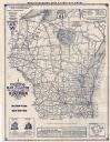
| Date: | 1929 |
|---|---|
| Description: | This map shows the entire state of Wisconsin and Minnesota and portions of Illinois and Iowa. Counties, cities, highways, lakes, and rivers are labeled. Ro... |
If you didn't find the material you searched for, our Library Reference Staff can help.
Call our reference desk at 608-264-6535 or email us at: