 Filter: Categories of Wisconsin Historical Images
Filter: FULL_DATE of 1929
Filter: Subject of human settlements
Filter: Categories of Wisconsin Historical Images
Filter: FULL_DATE of 1929
Filter: Subject of human settlements

| Date: | 1929 |
|---|---|
| Description: | View down unpaved street scene towards an intersection. A tree and a fire hydrant on the corner on the left. On the right is a garage with a ramp entrance ... |

| Date: | 1929 |
|---|---|
| Description: | View looking down at the dam on the Kickapoo River. Houses are on the far side of the river, and chimneys are blowing heavy smoke. In the far background is... |

| Date: | 1929 |
|---|---|
| Description: | View across field of front exterior of a stone church. There is a belfry but no steeple. Stained glass windows are at the front, side, and above the entran... |
| Date: | 1929 |
|---|---|
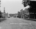
| Description: | View down middle of street towards central business section. On the left is a building with a belfry. Cars and businesses line both sides of the street, pe... |
| Date: | 1929 |
|---|---|
| Description: | View down middle of Main Street paved with cobblestones. There is a railroad crossing at the far end, and the ridge of a hill in the far background. A barb... |
| Date: | 1929 |
|---|---|
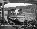
| Description: | View from pier of a Native American man wearing a headdress kneeling on a tourist boat called "Black Hawk" docked under a bridge in the Wisconsin River. He... |

| Date: | 1929 |
|---|---|
| Description: | High suspension bridge over gorge at Constantine in north eastern Algeria. |
| Date: | 1929 |
|---|---|
| Description: | Outside the walls of Tebessa, in north eastern Algeria. Hills are in the far background. |

| Date: | 1929 |
|---|---|
| Description: | View across street towards three women standing on the front steps of Winnes Inn, a converted dwelling in a residential neighborhood. |

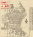
| Date: | 1929 |
|---|---|
| Description: | This is a blue line print map that shows local streets, railroads, local businesses, schools, parks, cemeteries, the airport, the state capitol, the Univer... |

| Date: | 1929 |
|---|---|
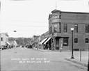
| Description: | View from street towards the Denmark State Bank, which is heavily covered with ivy. There is a flagpole at the corner flying the American flag. Caption rea... |
| Date: | 1929 |
|---|---|
| Description: | This map shows streets, railroads, parks, cemeteries, and a proposed harbor. The top margin includes an advertisement for Delco Motor Oil and the right mar... |
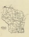
| Date: | 1929 |
|---|---|
| Description: | This map shows railroad routes throughout the state. |

| Date: | 1929 |
|---|---|
| Description: | View across street towards the F.W. Woolworth Co. 5 and 10 Cent Store, a large building at 1-5 E. Main Street at the corner of Monona Avenue (now Martin Lu... |

| Date: | 1929 |
|---|---|
| Description: | View across street towards the First National Bank and Central Wisconsin Trust Company on the corner of East Washington Avenue and S. Pinckney Street. The ... |

| Date: | 1929 |
|---|---|
| Description: | View from street of the First National Bank and Central Wisconsin Trust Company in the 100 block of South Pinckney Street. Other businesses include the Cho... |

| Date: | 1929 |
|---|---|
| Description: | Shingle-sided home at 1502 Fremont Avenue, built in 1929. Trees and shrubs surround the house. |

| Date: | 1929 |
|---|---|
| Description: | View from across street towards the first block of East Mifflin Street. The businesses are, from left to right: The Strand Theater, Kinney Shoes, Hughes Wo... |

| Date: | 1929 |
|---|---|
| Description: | Three men are sitting in delivery trucks in front of a building. The building has a sign that reads: "Saskatchewan-Co-Operative Creameries Ltd." |

| Date: | 1929 |
|---|---|
| Description: | This plat map shows land parcels, blocks and streets located in a portion of the Mendota Beach subdivision. Streets include Adelia Street, Wesley Avenue, B... |
If you didn't find the material you searched for, our Library Reference Staff can help.
Call our reference desk at 608-264-6535 or email us at: