 Filter: Categories of Wisconsin Historical Images
Filter: FULL_DATE of 1929
Filter: Type of Map or Atlas
Filter: Subject of architecture
Filter: Categories of Wisconsin Historical Images
Filter: FULL_DATE of 1929
Filter: Type of Map or Atlas
Filter: Subject of architecture

| Date: | 1929 |
|---|---|
| Description: | This 1929 topographic map of Trempealeau County, Wisconsin, shows the topography, lakes, streams and wetlands, township and range grid, sections, cities an... |

| Date: | 1929 |
|---|---|
| Description: | Map shows townships and sections, landownership and acreages, roads, schools, school districts, churches, and cemeteries. Includes index of acreage tracts. |

| Date: | 1929 |
|---|---|
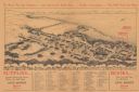
| Description: | This map is oriented with north to the upper right. Includes index of retailers and buildings, with some advertisements in margins. |

| Date: | 1929 |
|---|---|
| Description: | Shows fraternities, sororities, major rooming houses, private and university buildings, and university property. Oriented with north slightly to the right. |
| Date: | 1929 |
|---|---|
| Description: | Bird’s-eye view map. Top of map reads: "To Show You the Campus ... and Gatewood's Book Store ... Further Instructions ... You Will Need No More". Bottom le... |

| Date: | 1929 |
|---|---|
| Description: | This is a blue line print map that shows local streets, railroads, local businesses, schools, parks, cemeteries, the airport, the state capitol, the Univer... |

| Date: | 1929 |
|---|---|
| Description: | This map includes illustrations and shows campus buildings, points of interest in the surrounding area, railroads, Lake Mendota and Lake Monona. The back o... |
If you didn't find the material you searched for, our Library Reference Staff can help.
Call our reference desk at 608-264-6535 or email us at: