 Filter: Categories of Wisconsin Historical Images
Filter: FULL_DATE of 1928
Filter: Subject of roads
Filter: Categories of Wisconsin Historical Images
Filter: FULL_DATE of 1928
Filter: Subject of roads
| Date: | 1928 |
|---|---|
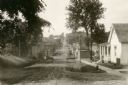
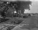
| Description: | View down dirt road. Houses are on the right. Further down the road are commercial buildings and automobiles. |

| Date: | 1928 |
|---|---|
| Description: | University of Wisconsin-Madison, looking west. Lake Mendota and Picnic Point are in the upper right of the image. Bascom Hall, the Red Gym, the Wisconsin H... |

| Date: | 1928 |
|---|---|
| Description: | View across road of exterior of building on the University of Wisconsin-Madison campus. Cars are parked along University Avenue. |
| Date: | 1928 |
|---|---|
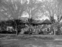
| Description: | An exterior view of the home of William Llewellyn and Zona Gale Breese. The brick and stucco house has features of several styles. The original 1912 struct... |
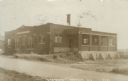
| Date: | 1928 |
|---|---|
| Description: | View of the Black Hawk State Bank, an automotive repair and gas station and other shops. There is a car with its door open in front of the repair shop, nea... |
| Date: | 1928 |
|---|---|
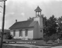
| Description: | Exterior view of church building with a bell tower, arched windows, french doors, a fanlight, and a sign that read "M.E. Church." |
| Date: | 1928 |
|---|---|
| Description: | View across road of two men posing outside a creamery. The creamery has a roofed loading dock on the side. |

| Date: | 1928 |
|---|---|
| Description: | Exterior view of gas station/restaurant outside the Triangle Tourist Park. The establishment offers Red Crown brand gasoline, Coney Island Red Hots, hot co... |

| Date: | 1928 |
|---|---|
| Description: | Map of portions of Wisconsin and Minnesota between Lake Superior and Mississippi River, showing railroads and military road. |
| Date: | 1928 |
|---|---|
| Description: | View down road of a man and young girl posing near their car at the Iowa welcome sign on an archway over the road. In the background are advertisements for... |

| Date: | 1928 |
|---|---|
| Description: | Winter scene with a plowed road and automobile stuck in a snowbank. There is a snowplow in the background. |

| Date: | 1928 |
|---|---|
| Description: | This 1928 topographic map of Vernon County, Wisconsin, shows relief, lakes, streams and wetlands, the township and range grid, sections, cities and village... |

| Date: | 1928 |
|---|---|
| Description: | Shows different types of roads, railroads, schools, churches, farmsteads, cheese factories, mine shafts, old surface workings, streams, old sulphur pits, a... |
| Date: | 1928 |
|---|---|
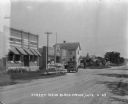
| Description: | View down road towards a filling station near Portage. A man stands while filling his tank. Two boys stand nearby. Under large trees are two pumps, a small... |
| Date: | 1928 |
|---|---|
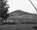
| Description: | View down valley of a procession of hundreds of pilgrims walking up the hill to St. Anne's Chapel which is lined with Stations of the Cross. The crowd is w... |
| Date: | 1928 |
|---|---|
| Description: | Photographic postcard view across road of the creamery. The entrance is on the left and a loading dock is on the right. Caption reads: "'Creamery,' Baldwin... |

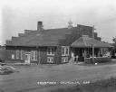
| Date: | 1928 |
|---|---|
| Description: | View from driveway with stone columns, over road towards the entrance gate to the Pine Grove Camp. People are standing near an automobile, tents and an out... |

| Date: | 1928 |
|---|---|
| Description: | This map shows the Forest Hill Cemetery and is oriented with the north to the lower left. The map shows buildings and section numbers but does not include ... |
If you didn't find the material you searched for, our Library Reference Staff can help.
Call our reference desk at 608-264-6535 or email us at:

