 Filter: Categories of Wisconsin Historical Images
Filter: FULL_DATE of 1928
Filter: Subject of rivers
Filter: Categories of Wisconsin Historical Images
Filter: FULL_DATE of 1928
Filter: Subject of rivers
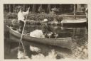
| Date: | 1928 |
|---|---|
| Description: | President Calvin Coolidge fishing at Cedar Island Lodge, rustic lodge of Henry C. Pierce, 35 miles from Superior, Wisconsin, on the Brule River. This lodge... |
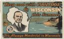
| Date: | 1928 |
|---|---|
| Description: | "Keep Cool with Coolidge in Wisconsin This Summer." A stamp presumably issued by the Outdoor Club of Wisconsin, to promote tourism in northern Wisconsin. I... |
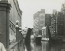
| Date: | 1928 |
|---|---|
| Description: | An open drawbridge with a boat crossing below. The First National Bank is in the background. |
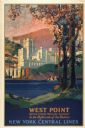
| Date: | 1928 |
|---|---|
| Description: | An original lithograph promoting New York Central Lines railway and the West Point military academy, in a location described as being "In the highlands of ... |

| Date: | 1928 |
|---|---|
| Description: | Illustrated map of points of interest, including University buildings, parks, athletic venues, fraternity and sorority houses, and state buildings. |

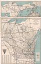
| Date: | 1928 |
|---|---|
| Description: | This map shows the state trunk highway system and county trunk highways. The lower left corner includes a legend of roadway types. Lake Michigan and Lake S... |

| Date: | 1928 |
|---|---|
| Description: | This map shows county boundaries, cities, rivers, lakes, roads and points of interest. Included are portions of Minnesota, Iowa, Illinois, and Michigan. La... |

| Date: | 1928 |
|---|---|
| Description: | This map shows roads, cities, lakes, rivers, points of interest and county boundaries. Through routes are outlined in red. Includes an index to cities and ... |
| Date: | 1928 |
|---|---|
| Description: | This map shows U.S., state, county highways, cities, county boundaries, lakes, rivers, and points of interest. At the top of the map it shows the Upper Mic... |

| Date: | 1928 |
|---|---|
| Description: | This map shows roadways, cities, rivers, and lakes. Included are portions of Minnesota, Iowa, and Illinois. Lake Michigan is on the far left side, with Lak... |
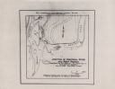
| Date: | 1928 |
|---|---|
| Description: | This map shows the junction between the Montreal River and the west branch of the Montreal River. The original captions on the map read: "Field Work by H.R... |

| Date: | 1928 |
|---|---|
| Description: | This map shows the entire state of Wisconsin as well as portions of Michigan, Minnesota, Iowa and Illinois. Lake Michigan, Lake Superior, Lake Winnebago a... |

| Date: | 1928 |
|---|---|
| Description: | Birds-eye view showing Lake Mendota, Lake Monona, Lake Wingra, Lake Waubesa and Lake Kegonsa. Shows the growth of Madison from the Isthmus along the southe... |
If you didn't find the material you searched for, our Library Reference Staff can help.
Call our reference desk at 608-264-6535 or email us at: