 Filter: Categories of Wisconsin Historical Images
Filter: FULL_DATE of 1928
Filter: Subject of lakes
Filter: Categories of Wisconsin Historical Images
Filter: FULL_DATE of 1928
Filter: Subject of lakes

| Date: | 1928 |
|---|---|
| Description: | Administrative building of the State Fish Hatchery. |

| Date: | 1928 |
|---|---|
| Description: | Aerial view of Madison looking southeast over the isthmus, showing the Four Lakes Country. Visible at the bottom is the Lake Mendota shoreline. At center, ... |
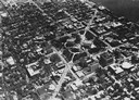
| Date: | 1928 |
|---|---|
| Description: | Aerial view of Capitol Square and vicinity, looking east-northeast. State Street is visible at the bottom center. |

| Date: | 1928 |
|---|---|
| Description: | An aerial view of the buildings and grounds of the Wisconsin Memorial Hospital, located at Farwell's Point. |

| Date: | 1928 |
|---|---|
| Description: | University of Wisconsin-Madison, looking west. Lake Mendota and Picnic Point are in the upper right of the image. Bascom Hall, the Red Gym, the Wisconsin H... |
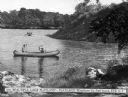
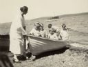
| Date: | 1928 |
|---|---|
| Description: | View from shoreline toward a woman in a canoe holding a parasol as an accompanying man paddles through the water near a wooded shore at Playland. Other row... |
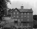
| Date: | 1928 |
|---|---|
| Description: | A young man fishes on the rocky shore by the Old Mill. The Mill is three-stories high and features a cupola with a wind vane on top. |
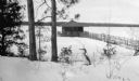
| Date: | 1928 |
|---|---|
| Description: | A juvenile loon stands in the snow on the hill above Europe Lake. The Hotz boathouse, with its walkway and rustic railing, is in the background. |

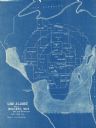
| Date: | 1928 |
|---|---|
| Description: | This 1928 topographic map of Vernon County, Wisconsin, shows relief, lakes, streams and wetlands, the township and range grid, sections, cities and village... |

| Date: | 1928 |
|---|---|
| Description: | Illustrated map of points of interest, including University buildings, parks, athletic venues, fraternity and sorority houses, and state buildings. |

| Date: | 1928 |
|---|---|
| Description: | View down slope towards Deep Lake. There is a girl standing in a rowboat at the shoreline. She is holding up her catch of the day. In the background a man ... |

| Date: | 1928 |
|---|---|
| Description: | View from hill of Jordan Lake. Two people are fishing in a rowboat below, and the wooded far shoreline is in the distance. |

| Date: | 1928 |
|---|---|
| Description: | William O. Petersen, youngest son of William F. and Alma Schmidt Petersen, plays at the Geneva Lake shore. There is a picnic basket in the background and a... |
| Date: | 1928 |
|---|---|
| Description: | Alma Schmidt Petersen, standing on the shore of Geneva Lake at Black Point, steadies a rowboat with her three sons and two other boys in it. Conrad Peterse... |
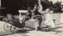
| Date: | 1928 |
|---|---|
| Description: | Conrad, resting his feet in a baby carriage, and Edward, center, sit on a bench on the pier at Black Point; their younger brother William stands at right. ... |

| Date: | 1928 |
|---|---|
| Description: | This map shows the state trunk highway system and county trunk highways. The lower left corner includes a legend of roadway types. Lake Michigan and Lake S... |
| Date: | 1928 |
|---|---|
| Description: | This blue line map shows the number of carload shipments to northern and central counties, with Mosinee being the central distribution point. Lake Michigan... |

| Date: | 1928 |
|---|---|
| Description: | This map shows county boundaries, cities, rivers, lakes, roads and points of interest. Included are portions of Minnesota, Iowa, Illinois, and Michigan. La... |

| Date: | 1928 |
|---|---|
| Description: | This map shows roads, cities, lakes, rivers, points of interest and county boundaries. Through routes are outlined in red. Includes an index to cities and ... |
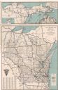
| Date: | 1928 |
|---|---|
| Description: | This map shows U.S., state, county highways, cities, county boundaries, lakes, rivers, and points of interest. At the top of the map it shows the Upper Mic... |
If you didn't find the material you searched for, our Library Reference Staff can help.
Call our reference desk at 608-264-6535 or email us at: