Filter: Categories of Wisconsin Historical Images
Filter: FULL_DATE of 1928
Filter: Subject of human settlements
Filter: Categories of Wisconsin Historical Images
Filter: FULL_DATE of 1928
Filter: Subject of human settlements
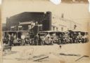
| Date: | 1928 |
|---|---|
| Description: | Six trucks and a car are parked in front of the Central Baking Company building. Most of the vehicles are decorated with flags and streamers for a parade. ... |

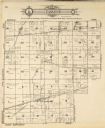
| Date: | 1928 |
|---|---|
| Description: | This 1928 topographic map of Vernon County, Wisconsin, shows relief, lakes, streams and wetlands, the township and range grid, sections, cities and village... |
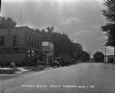
| Date: | 1928 |
|---|---|
| Description: | View down street. On the left is the McCann. Undertaking building and grocery store. Two children play on a wagon on the sidewalk. Five people are gathered... |
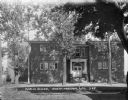
| Date: | 1928 |
|---|---|
| Description: | Facade of brick building, with stone steps and a columned entrance. On the left near the corner of the building is a cart, and along the side there appears... |
| Date: | 1928 |
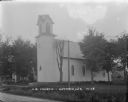
|---|---|
| Description: | Exterior view of the United Brethren Church which has an arched window above the entrance and arched windows along the sides. Trees and homes surround the ... |
| Date: | 1928 |
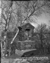
|---|---|
| Description: | Way of the Cross station leading to St Anne's Shrine. Behind the shrine are birch and other trees and a view down the hill towards a valley. The station is... |
| Date: | 1928 |
|---|---|
| Description: | This plat map of Wausau is oriented with north to the right and is dated "April, 1928." The map features a building description chart with an index and inc... |

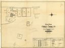
| Date: | 1928 |
|---|---|
| Description: | This map shows the Forest Hill Cemetery and is oriented with the north to the lower left. The map shows buildings and section numbers but does not include ... |

| Date: | 1928 |
|---|---|
| Description: | View from grassy hill of uptown Cross Plains. The Catholic Church (St. Francis Xavier) is on the right, and farmhouses and other buildings are among fields... |

| Date: | 1928 |
|---|---|
| Description: | View down valley towards the back of the Lutheran Church and cemetery. Houses and barns are in the valley below, and more hills are in the far background. ... |

| Date: | 1928 |
|---|---|
| Description: | Exterior view of the Elmer Droster home at 5301 Felland Road. There is a garage on the left, and in the far background a ridge with trees. |

| Date: | 1928 |
|---|---|
| Description: | This map shows the state trunk highway system and county trunk highways. The lower left corner includes a legend of roadway types. Lake Michigan and Lake S... |

| Date: | 1928 |
|---|---|
| Description: | This map shows a view of the Milwaukee metropolitan area. It highlights state trunk highways, principal county trunks and other secondary highways and type... |
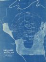
| Date: | 1928 |
|---|---|
| Description: | This blue line map shows the number of carload shipments to northern and central counties, with Mosinee being the central distribution point. Lake Michigan... |

| Date: | 1928 |
|---|---|
| Description: | This map shows county boundaries, cities, rivers, lakes, roads and points of interest. Included are portions of Minnesota, Iowa, Illinois, and Michigan. La... |

| Date: | 1928 |
|---|---|
| Description: | This map shows roads, cities, lakes, rivers, points of interest and county boundaries. Through routes are outlined in red. Includes an index to cities and ... |
| Date: | 1928 |
|---|---|
| Description: | This map shows U.S., state, county highways, cities, county boundaries, lakes, rivers, and points of interest. At the top of the map it shows the Upper Mic... |

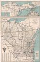
| Date: | 1928 |
|---|---|
| Description: | This map shows roadways, cities, rivers, and lakes. Included are portions of Minnesota, Iowa, and Illinois. Lake Michigan is on the far left side, with Lak... |

| Date: | 1928 |
|---|---|
| Description: | A Wisconsin state highway map, featuring the major highways, rivers, lakes, and cities. There are a few advertisements on the front and back. The back also... |
If you didn't find the material you searched for, our Library Reference Staff can help.
Call our reference desk at 608-264-6535 or email us at: