Filter: Categories of Wisconsin Historical Images
Filter: FULL_DATE of 1928
Filter: Subject of human settlements
Filter: Subject of cities and towns
Filter: Categories of Wisconsin Historical Images
Filter: FULL_DATE of 1928
Filter: Subject of human settlements
Filter: Subject of cities and towns
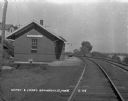
| Date: | 1928 |
|---|---|
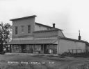
| Description: | A general store and gas station with a car parked in front. |
| Date: | 1928 |
|---|---|
| Description: | The exterior of the white public school building. Trees and bushes partially obstruct the view. |
| Date: | 1928 |
|---|---|
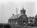
| Description: | The exterior of Saint Mary's Church. The building features lancet arches and a steeple with a cross atop. |
| Date: | 1928 |
|---|---|
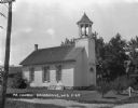
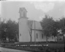
| Description: | Exterior view of church building with a bell tower, arched windows, french doors, a fanlight, and a sign that read "M.E. Church." |
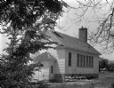
| Date: | 1928 |
|---|---|
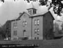
| Description: | The exterior of the public school building. A man sits on the steps. |

| Date: | 1928 |
|---|---|
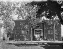
| Description: | View across road of the Village Inn; featuring a "Hotel" sign, vines along the screened porch windows, and a fenced garden. |

| Date: | 1928 |
|---|---|
| Description: | This map shows geological formations throughout Wisconsin. Lakes and rivers are labeled, including The Mississippi River, Lake Superior, and Lake Michigan.... |
| Date: | 1928 |
|---|---|
| Description: | Exterior view of the Church Post Office and general store. Signs painted on the window say: "Hardware, Paints, Oils." |

| Date: | 1928 |
|---|---|
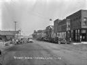
| Description: | View across commercial street looking south. Parked at the curb are cars, and driving along the street is a bearded man with a horse and buggy. The shops a... |

| Date: | 1928 |
|---|---|
| Description: | Exterior view of gas station/restaurant outside the Triangle Tourist Park. The establishment offers Red Crown brand gasoline, Coney Island Red Hots, hot co... |
| Date: | 1928 |
|---|---|
| Description: | View down a commercial street. An automotive repair shop is located on the left side of the street. |
| Date: | 1928 |
|---|---|
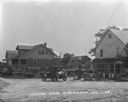
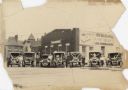
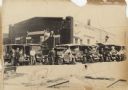
| Description: | Six trucks and a car are parked in front of the Central Baking Company. Most of the vehicles are decorated with flags and streamers for a parade. The truck... |
| Date: | 1928 |
|---|---|
| Description: | Six trucks and a car are parked in front of the Central Baking Company building. Most of the vehicles are decorated with flags and streamers for a parade. ... |

| Date: | 1928 |
|---|---|
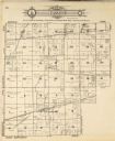
| Description: | This 1928 topographic map of Vernon County, Wisconsin, shows relief, lakes, streams and wetlands, the township and range grid, sections, cities and village... |
| Date: | 1928 |
|---|---|
| Description: | Facade of brick building, with stone steps and a columned entrance. On the left near the corner of the building is a cart, and along the side there appears... |
| Date: | 1928 |
|---|---|
| Description: | Exterior view of the United Brethren Church which has an arched window above the entrance and arched windows along the sides. Trees and homes surround the ... |
| Date: | 1928 |
|---|---|
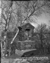
| Description: | Way of the Cross station leading to St Anne's Shrine. Behind the shrine are birch and other trees and a view down the hill towards a valley. The station is... |
| Date: | 1928 |
|---|---|
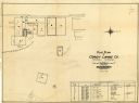
| Description: | This plat map of Wausau is oriented with north to the right and is dated "April, 1928." The map features a building description chart with an index and inc... |
If you didn't find the material you searched for, our Library Reference Staff can help.
Call our reference desk at 608-264-6535 or email us at: