 Filter: Categories of Wisconsin Historical Images
Filter: FULL_DATE of 1928
Filter: Subject of cemeteries
Filter: Categories of Wisconsin Historical Images
Filter: FULL_DATE of 1928
Filter: Subject of cemeteries

| Date: | 1928 |
|---|---|
| Description: | This 1928 topographic map of Vernon County, Wisconsin, shows relief, lakes, streams and wetlands, the township and range grid, sections, cities and village... |
| Date: | 1928 |
|---|---|
| Description: | View down valley of a procession of hundreds of pilgrims walking up the hill to St. Anne's Chapel which is lined with Stations of the Cross. The crowd is w... |

| Date: | 1928 |
|---|---|
| Description: | This map shows the Forest Hill Cemetery and is oriented with the north to the lower left. The map shows buildings and section numbers but does not include ... |

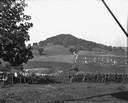
| Date: | 1928 |
|---|---|
| Description: | View down valley towards the back of the Lutheran Church and cemetery. Houses and barns are in the valley below, and more hills are in the far background. ... |
If you didn't find the material you searched for, our Library Reference Staff can help.
Call our reference desk at 608-264-6535 or email us at: