 Filter: Categories of Wisconsin Historical Images
Filter: FULL_DATE of 1927
Filter: Subject of rivers
Filter: Categories of Wisconsin Historical Images
Filter: FULL_DATE of 1927
Filter: Subject of rivers

| Date: | 1927 |
|---|---|
| Description: | Color map, hand-drawn with comic figures engaged in various activities throughout map. Bordered by the river on the left and Lake Michigan on the right, in... |
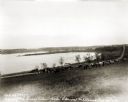
| Date: | 1927 |
|---|---|
| Description: | View down hill towards the Fox River from the Eleazer Williams home. A group of people are automobiles are near a road near the shoreline. |
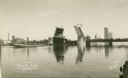
| Date: | 1927 |
|---|---|
| Description: | Main Street Bridge raised to let boats pass through the locks on the Fox River. |

| Date: | 1927 |
|---|---|
| Description: | Sons of Norway group in traditional Norwegian costume standing on a replica of a viking ship as part of the Fall Festival. A large American flag flies from... |

| Date: | 1927 |
|---|---|
| Description: | The Beaufort river waterfront as seen from Lady's Island bridge. There are wooden buildings, piers and a tree-line in the background. |
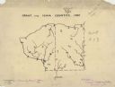
| Date: | 1927 |
|---|---|
| Description: | A hand-drawn map outlining the counties of Grant and Iowa counties as they would have appeared in 1837. |
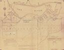
| Date: | 1927 |
|---|---|
| Description: | Shows landowner's lots, roads, railroads, and Fox River. Also includes certificate of survey text. Includes significant manuscript annotations depicting th... |

| Date: | 1927 |
|---|---|
| Description: | Street railway and motor bus map with a legend of "Street Car Line," "Auxiliary Bus Lines," and "Motor Bus Lines." The routes are numbered. The map reads: ... |

| Date: | 1927 |
|---|---|
| Description: | Shows campus buildings, points of interest in surrounding area, and railroads. Advertisements on verso. |

| Date: | 1927 |
|---|---|
| Description: | This map shows highways, roads, a proposed annexation, street car lines, bus routes, local motor bus lines, a new high speed interurban, railroads, a propo... |

| Date: | 1927 |
|---|---|
| Description: | This map shows the state trunk highway system and county trunk highways. The lower left corner includes a legend of roadway types. Lake Michigan and Lake S... |

| Date: | 1927 |
|---|---|
| Description: | This map shows roads, highways, cities, county boundaries, rivers, lakes and trails. The route from Chicago to Duluth (including Wisconsin Highways 13 and ... |

| Date: | 1927 |
|---|---|
| Description: | These maps are compiled from existing maps created by the Joint Engineering Department, the Wisconsin Railroad, and the Tax Commissions. The maps include n... |
If you didn't find the material you searched for, our Library Reference Staff can help.
Call our reference desk at 608-264-6535 or email us at: