 Filter: Categories of Wisconsin Historical Images
Filter: FULL_DATE of 1927
Filter: Subject of michigan, lake
Filter: Categories of Wisconsin Historical Images
Filter: FULL_DATE of 1927
Filter: Subject of michigan, lake

| Date: | 1927 |
|---|---|
| Description: | Color map, hand-drawn with comic figures engaged in various activities throughout map. Bordered by the river on the left and Lake Michigan on the right, in... |
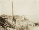
| Date: | 1927 |
|---|---|
| Description: | View from a hill looking down on the plant which has several attached buildings, and a large chimney. To the right are railroad cars along the shoreline o... |
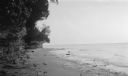
| Date: | 1927 |
|---|---|
| Description: | Rock outcroppings overhang a Door County beach. |
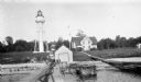
| Date: | 1927 |
|---|---|
| Description: | View of the Plum Island rear range lighthouse from the end of the pier. The brick house was home to the lighthouse keeper and the first and second assistan... |
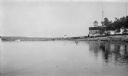
| Date: | 1927 |
|---|---|
| Description: | View from the water of the Plum Island U.S. Coast Guard station. There is a tower in the background. Long piers extend into the lake. |
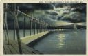
| Date: | 1927 |
|---|---|
| Description: | Hand-colored postcard view of a pier and lighthouse at night. The moon shines through clouds, and light shines in two directions from the beacon on top of ... |

| Date: | 1927 |
|---|---|
| Description: | Street railway and motor bus map with a legend of "Street Car Line," "Auxiliary Bus Lines," and "Motor Bus Lines." The routes are numbered. The map reads: ... |

| Date: | 1927 |
|---|---|
| Description: | This map shows street car lines, bus routes, railroads, proposed city boundary lines, wards, public schools, blocks & house numbers, Lake Michigan, one mil... |

| Date: | 1927 |
|---|---|
| Description: | This map shows highways, roads, a proposed annexation, street car lines, bus routes, local motor bus lines, a new high speed interurban, railroads, a propo... |

| Date: | 1927 |
|---|---|
| Description: | This map shows the state trunk highway system and county trunk highways. The lower left corner includes a legend of roadway types. Lake Michigan and Lake S... |

| Date: | 1927 |
|---|---|
| Description: | This map shows roads, highways, cities, county boundaries, rivers, lakes and trails. The route from Chicago to Duluth (including Wisconsin Highways 13 and ... |

| Date: | 1927 |
|---|---|
| Description: | This map details automobile routes throughout the state as well as parts of Iowa, Minnesota, Michigan and Illinois. Cities, the Mississippi River, Lake Mic... |
If you didn't find the material you searched for, our Library Reference Staff can help.
Call our reference desk at 608-264-6535 or email us at:
