 Filter: Categories of Wisconsin Historical Images
Filter: FULL_DATE of 1927
Filter: Subject of lakes
Filter: Categories of Wisconsin Historical Images
Filter: FULL_DATE of 1927
Filter: Subject of lakes
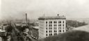
| Date: | 1927 |
|---|---|
| Description: | Elevated view looking east from the Wisconsin State Capitol down East Washington Avenue. |

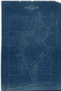
| Date: | 1927 |
|---|---|
| Description: | Blueprint-style map of Frost Woods on the shore of Lake Monona. The map indicates the locations of Indian mounds, an Indian camp, and various plants. There... |

| Date: | 1927 |
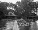
|---|---|
| Description: | Two women pose outside their lakefront cabin. |
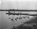
| Date: | 1927 |
|---|---|
| Description: | Lake view from the shore. A man, son, and two dogs stand at the dock. A herd of swans bathe nearby. |
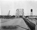
| Date: | 1927 |
|---|---|
| Description: | View down middle of metal bridge across the Cornell Flowage. Across the lake, there is the pulpwood stacker on the left and a water tower on the right near... |
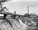
| Date: | 1927 |
|---|---|
| Description: | View across lower section of dam at Cornell Wood Products Company. In the background are factory buildings, a tall smokestack, and a water tower. |
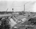
| Date: | 1927 |
|---|---|
| Description: | Elevated view over dam of the site of the Cornell Wood Products Company. On the opposite shoreline is a pulpwood stacker, tall smokestack, water tower, and... |
| Date: | 1927 |
|---|---|
| Description: | View from the dock looking at a beached canoe and two housing structures at Ro-Mi-Moco Park. |

| Date: | 1927 |
|---|---|
| Description: | Picnic area of Olin Park, where a woman reads a newspaper on a park bench. |

| Date: | 1927 |
|---|---|
| Description: | This 1927 map of Sawyer County, Wisconsin, shows the township and range system, sections, cities and villages, roads, railroads, and lakes and streams. |

| Date: | 1927 |
|---|---|
| Description: | Shows campus buildings, points of interest in surrounding area, and railroads. Advertisements on verso. |
| Date: | 1927 |
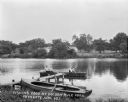
|---|---|
| Description: | View from shoreline of a pair of men fishing in a lake. Another rowboat is tied at a pier in the foreground. On the far shoreline are cottages and trees. |

| Date: | 1927 |
|---|---|
| Description: | Map reads: "Now You Can Visualize Madison". Includes indexes, with points marked 1-98 and a key. Text and illustrations on verso include hotels and seasona... |
| Date: | 1927 |
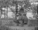
|---|---|
| Description: | A Native American boy and girl pose standing in front of a tipi on a hill by a lake. The tipi is covered with a fringed blanket. |

| Date: | 1927 |
|---|---|
| Description: | Four people, two men and two women, stand on a pier near an excursion boat on Lake Delton. A sign with flags is on top of the boat and reads: "Lake and Riv... |

| Date: | 1927 |
|---|---|
| Description: | Edward Schmidt Petersen sails a toy boat in the shallow waters near the shore of Geneva Lake at Black Point. There is a chair and another child in the fore... |

| Date: | 1927 |
|---|---|
| Description: | View across street towards the house at 130 East Gilman Street, which was built between 1854-1856. Lake Mendota is in the background. The stone building fe... |

| Date: | 1927 |
|---|---|
| Description: | This map shows the state trunk highway system and county trunk highways. The lower left corner includes a legend of roadway types. Lake Michigan and Lake S... |
| Date: | 1927 |
|---|---|
| Description: | This blueprint map shows landownership around the lake. Water depths are shown by soundings; relief is shown by hachures. The map was originally created in... |

| Date: | 1927 |
|---|---|
| Description: | View across water towards a boy standing on a pier on Lake Waubesa. There are boats docked at the water's edge and a group of children and adults are on th... |
If you didn't find the material you searched for, our Library Reference Staff can help.
Call our reference desk at 608-264-6535 or email us at: