 Filter: Categories of Wisconsin Historical Images
Filter: FULL_DATE of 1927
Filter: Subject of human settlements
Filter: Categories of Wisconsin Historical Images
Filter: FULL_DATE of 1927
Filter: Subject of human settlements

| Date: | 1927 |
|---|---|
| Description: | This map shows highways, roads, a proposed annexation, street car lines, bus routes, local motor bus lines, a new high speed interurban, railroads, a propo... |

| Date: | 1927 |
|---|---|
| Description: | View from street towards the corner of King Street and S. Pinckney Street. On the corner is the Haw-Olson Company. Down King Street is the Majestic Theater... |
| Date: | 1927 |
|---|---|
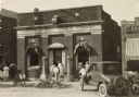
| Description: | View from street of the South Side State Bank on Lakeside Street, after a robbery. The front door is set in the center of the facade, flanked on both sides... |

| Date: | 1927 |
|---|---|
| Description: | View across street towards the house at 130 East Gilman Street, which was built between 1854-1856. Lake Mendota is in the background. The stone building fe... |

| Date: | 1927 |
|---|---|
| Description: | View across street towards 116-118 N. Fairchild Street towards a row of 1920s automobiles angle parked outside Esser's City Market. To the right of the mar... |

| Date: | 1927 |
|---|---|
| Description: | This map shows the state trunk highway system and county trunk highways. The lower left corner includes a legend of roadway types. Lake Michigan and Lake S... |
| Date: | 1927 |
|---|---|
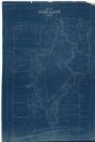
| Description: | This blueprint map shows landownership around the lake. Water depths are shown by soundings; relief is shown by hachures. The map was originally created in... |

| Date: | 1927 |
|---|---|
| Description: | This Blue line print map shows trade area boundaries, lakes, farm homes, railways, high schools, public highways, and townships. A symbol key is included i... |

| Date: | 1927 |
|---|---|
| Description: | This map shows roads, highways, cities, county boundaries, rivers, lakes and trails. The route from Chicago to Duluth (including Wisconsin Highways 13 and ... |

| Date: | 1927 |
|---|---|
| Description: | These maps are compiled from existing maps created by the Joint Engineering Department, the Wisconsin Railroad, and the Tax Commissions. The maps include n... |

| Date: | 1927 |
|---|---|
| Description: | View across street towards the Loraine Garage at 14 N. Fairchild Street. There is a painted sign on the building advertising parking for 50 cents. There ar... |

| Date: | 1927 |
|---|---|
| Description: | Oliver Hardy is pointing to Stan Laurel while the insurance agent (Eugene Pallette) looks at Laurel with concern. Laurel is holding his hat in his hand and... |

| Date: | 1927 |
|---|---|
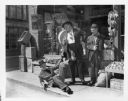
| Description: | Stan Laurel and Oliver Hardy standing on a sidewalk. They are both looking at a police officer sitting on the sidewalk holding a banana peel. Laurel is hol... |
| Date: | 1927 |
|---|---|
| Description: | Stan Laurel sitting on the sidewalk with one leg in the air. He is holding on to Oliver Hardy's coat. Hardy is holding a banana and is looking down at Laur... |

| Date: | 1927 |
|---|---|
| Description: | This map details automobile routes throughout the state as well as parts of Iowa, Minnesota, Michigan and Illinois. Cities, the Mississippi River, Lake Mic... |

| Date: | 1927 |
|---|---|
| Description: | View down Main Street, with the Eagle Hotel on the left. Automobiles and trucks are parked along the curbs. Caption reads: "Main Street — Looking South, Fo... |

| Date: | 1927 |
|---|---|
| Description: | Intersection of Trail 53 and Main Street, lined with buildings. A road sign is in the foreground, and rucks and automobiles are parked at the curb. A steep... |

| Date: | 1927 |
|---|---|
| Description: | Elevated view of the wagon bridge spanning the St. Croix River. An excursion boat is passing underneath the bridge. Hudson is on the far bank. Caption read... |

| Date: | 1927 |
|---|---|
| Description: | Illustration of the New Kenosha Theatre. The marquee is advertising "Swim, Girl, Swim" with Bebe Daniels. An advertisement is painted on the left side of t... |

| Date: | 1927 |
|---|---|
| Description: | Large group of people gathered in a centrally located park, with a row of shops across the street. There is a gazebo under the trees on the right. Caption ... |
If you didn't find the material you searched for, our Library Reference Staff can help.
Call our reference desk at 608-264-6535 or email us at: