 Filter: Categories of Wisconsin Historical Images
Filter: FULL_DATE of 1926
Filter: Categories of Wisconsin Historical Images
Filter: FULL_DATE of 1926

| Date: | 1926 |
|---|---|
| Description: | Studio portrait of the Cross Plains American Legion basketball team, coaches and assistants in front of a painted backdrop. The players wear uniforms, the ... |

| Date: | 1926 |
|---|---|
| Description: | Large group of students and teachers posed on a slope in front of St. Francis Xavier Catholic School for a group portrait. Many of the children and adults ... |
| Date: | 1926 |
|---|---|
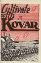
| Description: | Catalog cover featuring an illustration of a man driving a tractor and pulling a spring tooth digger in a field. The slogan: "Cultivate with Kovar" is over... |
| Date: | 1926 |
|---|---|
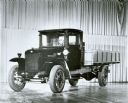
| Description: | Original caption reads: "International 'speed' trucks were introduced in 1921. They offered higher speeds to match road-development progress of the 1920's.... |

| Date: | 1926 |
|---|---|
| Description: | Florentina and Alexander Krueger posing in front of a Chevy Sedan. |

| Date: | 1926 |
|---|---|
| Description: | This map shows streets, railroads, parks, and cemeteries. The top right includes an advertisement for Bartles-Maguire Oil Co. Wards are colored in red, yel... |
| Date: | 1926 |
|---|---|
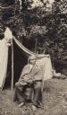
| Description: | John Nuwi wrapped in a blanket and seated in a chair in front of his summer tent at Skunk Hill.. |

| Date: | 1926 |
|---|---|
| Description: | This brochure was intended for tourists and shows resorts, lakes and railroads in northwestern Wisconsin and part of Michigan’s upper peninsula. Also inclu... |

| Date: | 1926 |
|---|---|
| Description: | Exterior view of the South Madison Chicago and North Western Railroad Station located next to the railroad tracks that cross Lakeside Street. In the foregr... |

| Date: | 1926 |
|---|---|
| Description: | William F. Petersen holds his son Conrad in the waters of Geneva Lake off the shore of Black Point. There are sailboats in the background. |

| Date: | 1926 |
|---|---|
| Description: | Conrad Petersen steps off the pier onto the shore at Black Point Estate. A small boat is moored to the shore in the background under a tree trunk leaning ... |

| Date: | 1926 |
|---|---|
| Description: | This map shows the state trunk highway system and county trunk highways. The lower left corner includes a legend of roadway types. Lake Michigan and Lake S... |

| Date: | 1926 |
|---|---|
| Description: | A group of women and children surround a woman who is standing on an X-Ray machine (fluoroscope) to determine if her shoes fit. A man on the right is opera... |

| Date: | 1926 |
|---|---|
| Description: | This blueprint manuscript map shows buildings, railroads, and United States property. Water depths shown by soundings, tints, and isolines. |

| Date: | 1926 |
|---|---|
| Description: | This blueprint map shows streets, industrial, and public buildings in the vicinity of harbor. |

| Date: | 1926 |
|---|---|
| Description: | This blueprint map shows the Sheboygan River, buildings, and roads in the vicinity of the harbor. The map has explanations including "dredging required to ... |
| Date: | 1926 |
|---|---|
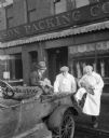
| Description: | Three men inspecting chickens in front of the Madison Packing Company located at 307 West Johnson Street. One of the men is identified as Norbert J. Noltne... |

| Date: | 1926 |
|---|---|
| Description: | View towards a woman standing at the meat counter of the Madison Packing Company. She is buying chickens from a man standing behind the counter which has a... |

| Date: | 1926 |
|---|---|
| Description: | This map includes a legend in the lower right corner of building heights. Districts marked "A" are 35 foot, districts marked "B" are 45 foot, districts mar... |

| Date: | 1926 |
|---|---|
| Description: | This map includes a legend in the lower right corner of land use. Districts are shown in five different shading for: "A" residential, "B" are residential, ... |
If you didn't find the material you searched for, our Library Reference Staff can help.
Call our reference desk at 608-264-6535 or email us at: