Filter: Categories of Wisconsin Historical Images
Filter: FULL_DATE of 1926
Filter: Subject of water
Filter: Categories of Wisconsin Historical Images
Filter: FULL_DATE of 1926
Filter: Subject of water
| Date: | 1926 |
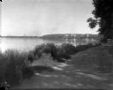
|---|---|
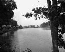
| Description: | Lake Mendota, including Fraternity Row and east side shoreline, taken from the lake path on University Bay Drive. |
| Date: | 1926 |
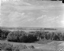
|---|---|
| Description: | Elevated view of Picnic Point on Lake Mendota from the University of Wisconsin-Madison Soils building. |
| Date: | 1926 |
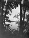
|---|---|
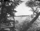
| Description: | View through willow trees on Picnic Point across University Bay of Lake Mendota on the University of Wisconsin-Madison campus. |
| Date: | 1926 |
|---|---|
| Description: | View of Picnic Point across University Bay on Lake Mendota. There is a willow tree in the foreground. People are in a canoe out on the water. |
| Date: | 1926 |
|---|---|
| Description: | View of Adams, Tripp and Van Hise Halls. All are residence halls on the University of Wisconsin campus with Picnic Point and Lake Mendota in the backgroun... |

| Date: | 1926 |
|---|---|
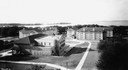
| Description: | Originally titled 'Recent Aeroplane View of University Campus', the view of the Wisconsin Historical Society, the Red Gym, Science Hall and Bascom Hall wit... |
| Date: | 1926 |
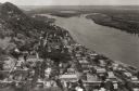
|---|---|
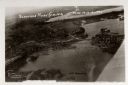
| Description: | Aerial view with Wisconsin River. Caption reads: "Schofield Home Coming June 16-17-18-1927". The wing of an airplane is in the right foreground. |

| Date: | 1926 |
|---|---|
| Description: | This hand-colored blueprint map shows landowners in part of T15N, R5E in Juneau County. North is oriented to the right. |
| Date: | 1926 |
|---|---|
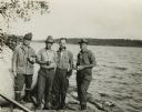
| Description: | Sigurd Olson, second from the left, with one of the early groups that he guided into the wilderness near Ely, Minnesota. The other men are identified as Dr... |
| Date: | 1926 |
|---|---|
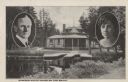
| Description: | Black and white postcard view of Cedar Island Lodge, located on the Brule River, owned by Henry Clay Pierce, businessman and financier. It was dubbed the S... |
| Date: | 1926 |
|---|---|
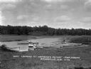
| Description: | View from shoreline of boat landing. A boy rows a boat nearby, and another boy fishes from a boat resting on the shoreline. |
| Date: | 1926 |
|---|---|
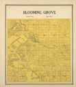
| Description: | Plat map of Blooming Grove Township in Dane County. |
| Date: | 1926 |
|---|---|
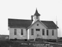
| Description: | Exterior of a schoolhouse with a hand-pump water well and flagpole in front. |
| Date: | 1926 |
|---|---|
| Description: | View from shoreline of mill pond. Industrial buildings are on the far shoreline. |
| Date: | 1926 |
|---|---|
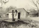
| Description: | A man pumps water from an old wooden pump into a tin cup. This photo was taken for International Harvester's Agricultural Extension Department to illustrat... |
| Date: | 1926 |
|---|---|
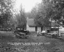
| Description: | A group of women and children sit at a picnic table at the Black Bridge Boat Livery off Highway 12. Behind them is a building with a screened porch facing ... |
| Date: | 1926 |
|---|---|
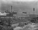
| Description: | The Wausau Sulphate Fibre Company grounds near a body of water. |
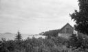
| Date: | 1926 |
|---|---|
| Description: | View of rustic cabin with a large stone chimney standing by the shore. There is another house or boathouse in the far background near the remains of a pier... |
If you didn't find the material you searched for, our Library Reference Staff can help.
Call our reference desk at 608-264-6535 or email us at: