 Filter: Categories of Wisconsin Historical Images
Filter: FULL_DATE of 1926
Filter: Subject of transportation
Filter: Categories of Wisconsin Historical Images
Filter: FULL_DATE of 1926
Filter: Subject of transportation

| Date: | 1926 |
|---|---|
| Description: | This blueprint map shows streets, industrial, and public buildings in the vicinity of harbor. |

| Date: | 1926 |
|---|---|
| Description: | This blueprint map shows the Sheboygan River, buildings, and roads in the vicinity of the harbor. The map has explanations including "dredging required to ... |
| Date: | 1926 |
|---|---|
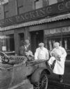
| Description: | Three men inspecting chickens in front of the Madison Packing Company located at 307 West Johnson Street. One of the men is identified as Norbert J. Noltne... |

| Date: | 1926 |
|---|---|
| Description: | This map includes a legend in the lower right corner of building heights. Districts marked "A" are 35 foot, districts marked "B" are 45 foot, districts mar... |

| Date: | 1926 |
|---|---|
| Description: | This map includes a legend in the lower right corner of land use. Districts are shown in five different shading for: "A" residential, "B" are residential, ... |

| Date: | 1926 |
|---|---|
| Description: | This blueprint map shows the land and its uses near Two Rivers Harbor. Lake Michigan is labeled on the left. Roads and buildings are also labeled. Original... |

| Date: | 1926 |
|---|---|
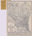
| Description: | This map shows road surfacings, camp sites, state parks, proposed state parks, rivers, lakes, county boundaries, and cities. Includes portions of Minnesota... |
| Date: | 1926 |
|---|---|
| Description: | This map shows paved roads, highways, road distances, cities, lakes, rivers, and county boundaries. Included are portions of Minnesota, Iowa, and Michigan.... |

| Date: | 1926 |
|---|---|
| Description: | This blueprint map shows the harbor at Kenosha, also showing buildings surrounding the harbor, roads, and railroads. Original caption in red states: "Areas... |

| Date: | 1926 |
|---|---|
| Description: | This blueprint map shows Manitowoc Harbor with depths represented by soundings. The upper right corner includes a "Description of Bench Marks". The map als... |

| Date: | 1926 |
|---|---|
| Description: | Two women are bending over in front of the plow on the left, pretending to pull a woman sitting on the back of the plow which is parked near a residential ... |

| Date: | 1926 |
|---|---|
| Description: | This blueprint map is oriented with north to the upper left. The map shows buildings with note of those "to be torn down," sidewalks, proposed power plant,... |

| Date: | 1926 |
|---|---|
| Description: | Colorized postcard of a paper factory beside a railroad track. Caption reads: "Hoberg Paper and Fibre Division, Green Bay, Wis." |
| Date: | 1926 |
|---|---|
| Description: | Corner view of the Y.M.C.A., a 5-story stone building. Automobiles parked at the curb. |

| Date: | 1926 |
|---|---|
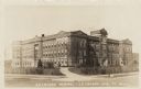
| Description: | View across drive and lawn towards the front of the building. Caption reads: "Brown County Asylum, Green Bay, Wis." |

| Date: | 1926 |
|---|---|
| Description: | View of a neighborhood street lined with single-family homes. Caption reads: "Scene on Ashland Avenue, West Side, Green Bay, Wis." |

| Date: | 1926 |
|---|---|
| Description: | Close-up of a man checking a drive chain on a binder. |
| Date: | 1926 |
|---|---|
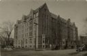
| Description: | Photographic postcard view of the Normal School, an original building for the University of Wisconsin-La Crosse located at 1724 State Street. Caption reads... |

| Date: | 1926 |
|---|---|
| Description: | Raymond (Ray) Griesemer is sitting on his Harley-Davidson motorcycle. He is wearing leather gloves, a jacket with sheepskin lining, dark pants, lace-up boo... |

| Date: | 1926 |
|---|---|
| Description: | Members of the extended Brumder family pose on a pier at the Wisconsin Dells. A motor launch with "Olson Boat Co" painted on the side is moored at the pier... |
If you didn't find the material you searched for, our Library Reference Staff can help.
Call our reference desk at 608-264-6535 or email us at: